IMAGES TAKEN NEAR TO
Hough Close, CHESTERFIELD, S40 2FJ
Introduction
This page details the photographs taken nearby to Hough Close, S40 2FJ by members of the Geograph project.
The Geograph project started in 2005 with the aim of publishing, organising and preserving representative images for every square kilometre of Great Britain, Ireland and the Isle of Man.

There are currently over 7.5m images from over14,400 individuals and you can help contribute to the project by visiting https://www.geograph.org.uk
Image Map
Images are licensed for reuse under creativecommons.org/licenses/by-sa/2.0
Notes
- Clicking on the map will re-center to the selected point.
- The higher the marker number, the further away the image location is from the centre of the postcode.
Image Listing (43 Images Found)
Images are licensed for reuse under creativecommons.org/licenses/by-sa/2.0
Image
Details
Distance
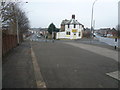
1
View to the famous twisted spire from near Hough Close in Chesterfield
Everywhere you go you can still often spot this landmark.
Image: © Jeremy Bolwell
Taken: 21 Jul 2020
0.02 miles
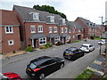
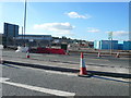
2
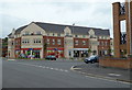
New shops off Redvers Buller Road
The shops serve a new housing development in a former industrial area.
Image: © Andrew Hill
Taken: 23 May 2011
0.05 miles
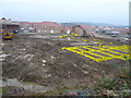
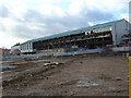
4
Chesterfield Cylinders
Being demolished for new housing development.
Image: © Stephen G Taylor
Taken: 17 Jul 2006
0.07 miles
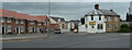
5
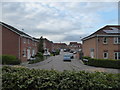
View of Baden Powell Road (R) and Redvers Buller Road (L)
Image: © Alan Heardman
Taken: 4 Jan 2008
0.08 miles
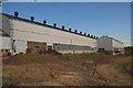
6
Demolition of Former Tube Works
Image: © Tony Bacon
Taken: 29 Nov 2007
0.09 miles
7
Redvers Buller Road off Baden Powell Road
Modern housing development is taking place in a former industrial area.
Image: © Andrew Hill
Taken: 23 May 2011
0.09 miles
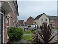
8
Part of Askew Way, Chesterfield
A nice estate of starter homes and retirement homes, with larger homes mixed in.
Image: © Jeremy Bolwell
Taken: 21 Jul 2020
0.10 miles
9
Former Donkins Site
This picture was taken across Derby Road (A61) as it approaches the Horn's Bridge roundabout. This land is currently in the process of re-development.
Image: © Alan Heardman
Taken: 4 Oct 2007
0.10 miles
10
View to the twisted spire from Askew Way, Chesterfield
The spire is often glimpsed in between buildings etc.
Image: © Jeremy Bolwell
Taken: 22 Jul 2020
0.10 miles