IMAGES TAKEN NEAR TO
Salcey Square, CHESTERFIELD, S40 2DX
Introduction
This page details the photographs taken nearby to Salcey Square, S40 2DX by members of the Geograph project.
The Geograph project started in 2005 with the aim of publishing, organising and preserving representative images for every square kilometre of Great Britain, Ireland and the Isle of Man.

There are currently over 7.5m images from over14,400 individuals and you can help contribute to the project by visiting https://www.geograph.org.uk
Image Map
Images are licensed for reuse under creativecommons.org/licenses/by-sa/2.0
Notes
- Clicking on the map will re-center to the selected point.
- The higher the marker number, the further away the image location is from the centre of the postcode.
Image Listing (8 Images Found)
Images are licensed for reuse under creativecommons.org/licenses/by-sa/2.0
Image
Details
Distance
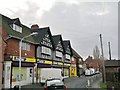
1
Walgrove Road from Bobbin Mill Lane
Image: © Stephen G Taylor
Taken: 18 Jul 2006
0.16 miles
2
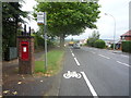
George V postbox on Walton Road
Postbox No. S40 179.
See Image] for close up
Image: © JThomas
Taken: 28 Jul 2016
0.20 miles
3
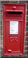
Close up, George V postbox on Walton Road
Postbox No. S40 179.
See Image] for wider view.
Image: © JThomas
Taken: 28 Jul 2016
0.20 miles
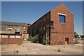
7
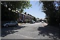
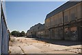
Chesterfield - Robinsons works
Photo taken from west end of Goytside Road. The west side of these works is shown in the photo Image
Image: © Dave Bevis
Taken: 9 Nov 2008
0.25 miles