IMAGES TAKEN NEAR TO
Stephenson Place, CHESTERFIELD, S40 1XL
Introduction
This page details the photographs taken nearby to Stephenson Place, S40 1XL by members of the Geograph project.
The Geograph project started in 2005 with the aim of publishing, organising and preserving representative images for every square kilometre of Great Britain, Ireland and the Isle of Man.

There are currently over 7.5m images from over14,400 individuals and you can help contribute to the project by visiting https://www.geograph.org.uk
Image Map
Images are licensed for reuse under creativecommons.org/licenses/by-sa/2.0
Notes
- Clicking on the map will re-center to the selected point.
- The higher the marker number, the further away the image location is from the centre of the postcode.
Image Listing (673 Images Found)
Images are licensed for reuse under creativecommons.org/licenses/by-sa/2.0
Image
Details
Distance


3

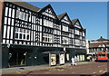
Chesterfield - Carters Bar (Holywell Street)
Eyres Furnishing Store is the building on the left hand side of the picture.
Image: © Alan Heardman
Taken: 22 Nov 1999
0.01 miles
4
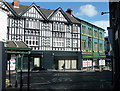
Stephenson Place, Chesterfield
View across the street from a passage way from the church.
Image: © Andrew Hill
Taken: 30 Apr 2012
0.01 miles
5
Stephenson Place, Chesterfield
One of numerous black and white half timbered buildings in the town. The street is largely dedicated to bus stops serving the town centre.
Image: © Andrew Hill
Taken: 29 Sep 2011
0.01 miles
6
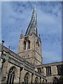
The crooked spire at Chesterfield
This is a picture of the unique crooked spire church at Chesterfield.
Image: © Dave and Carolyn Sawyer
Taken: 9 Sep 2003
0.01 miles
7
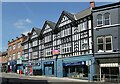
Sevens, Stephenson Place
Originally the Lord Nelson of William Stones brewery of Sheffield.
Image: © Alan Murray-Rust
Taken: 15 Jun 2021
0.02 miles
8
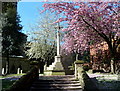
Chesterfield churchyard in the spring
A small space with trees in blossom between the church and the corner of Holywell Street.
Image: © Andrew Hill
Taken: 30 Apr 2012
0.02 miles
9
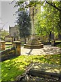
Cross in St Mary's Churchyard
The church in the background is the Church of St Mary and All Saints (Chesterfield Parish Church), a Grade I listed building famous for its twisted spire http://en.wikipedia.org/wiki/Church_of_St_Mary_and_All_Saints,_Chesterfield .
Image: © David Dixon
Taken: 4 Aug 2014
0.02 miles
