IMAGES TAKEN NEAR TO
Church Way, CHESTERFIELD, S40 1XJ
Introduction
This page details the photographs taken nearby to Church Way, S40 1XJ by members of the Geograph project.
The Geograph project started in 2005 with the aim of publishing, organising and preserving representative images for every square kilometre of Great Britain, Ireland and the Isle of Man.

There are currently over 7.5m images from over14,400 individuals and you can help contribute to the project by visiting https://www.geograph.org.uk
Image Map
Images are licensed for reuse under creativecommons.org/licenses/by-sa/2.0
Notes
- Clicking on the map will re-center to the selected point.
- The higher the marker number, the further away the image location is from the centre of the postcode.
Image Listing (663 Images Found)
Images are licensed for reuse under creativecommons.org/licenses/by-sa/2.0
Image
Details
Distance
1
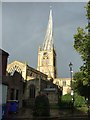
Church of St Mary and All Saints, Chesterfield
Commonly known as the Crooked Spire Church, building started in the 13th Century and finished around 1360. It is the largest church in Derbyshire, with the spire being some 228 feet tall and is visible from a good distance. The spire leans over 9 feet from true centre. Being originally built straight, the most plausible reason it became twisted is because of the use of green timber in its construction coupled with the 32 tons of lead which were placed on top.
Image: © JThomas
Taken: 7 Sep 2013
0.00 miles

3
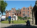
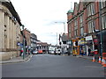
Town centre scene, Chesterfield
Looking past the porch of the parish church to town centre buildings.
Image: © Andrew Hill
Taken: 20 Jun 2011
0.01 miles
4
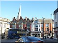
Shops in Stephenson Place
Can only be Chesterfield, famous for its crooked spire.
Image: © Christine Johnstone
Taken: 18 Oct 2018
0.01 miles
5
Town centre and parish church, Chesterfield
A view of the town centre and the famous crooked spire of the church of St Mary and All Saints.
Image: © Andrew Hill
Taken: 11 Nov 2010
0.01 miles
6

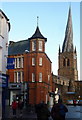
Benchmark on shop at Church Way - Stephenson Place junction
Ordnance Survey cut mark benchmark described on the Bench Mark Database at http://www.bench-marks.org.uk/bm40276
Image: © Roger Templeman
Taken: 29 Jun 2012
0.01 miles
7

toad shoeshop, #1-3 Stephenson Place
There is an OS benchmark Image between the green cabinet below the Church Way road name sign and the lamp post. The famous Chesterfield church spire can be seen in the background
Image: © Roger Templeman
Taken: 29 Jun 2012
0.01 miles
8
Stephenson Place - viewed from Knifesmithgate
Image: © Betty Longbottom
Taken: 10 Sep 2012
0.02 miles

10
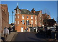
Church Way, Chesterfield
Looking north to the block of buildings immediately to the west of the church.
Image: © Andrew Hill
Taken: 16 Nov 2010
0.02 miles