IMAGES TAKEN NEAR TO
Rose Hill, CHESTERFIELD, S40 1TT
Introduction
This page details the photographs taken nearby to Rose Hill, S40 1TT by members of the Geograph project.
The Geograph project started in 2005 with the aim of publishing, organising and preserving representative images for every square kilometre of Great Britain, Ireland and the Isle of Man.

There are currently over 7.5m images from over14,400 individuals and you can help contribute to the project by visiting https://www.geograph.org.uk
Image Map
Images are licensed for reuse under creativecommons.org/licenses/by-sa/2.0
Notes
- Clicking on the map will re-center to the selected point.
- The higher the marker number, the further away the image location is from the centre of the postcode.
Image Listing (679 Images Found)
Images are licensed for reuse under creativecommons.org/licenses/by-sa/2.0
Image
Details
Distance
1
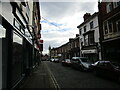
Glumangate, Chesterfield
The tower of the Market Hall in the distance.
Image: © Jonathan Thacker
Taken: 24 Feb 2023
0.01 miles
2
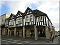
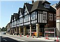
Neo-Tudor on Knifesmithgate, Chesterfield
Chesterfield has several blocks of Neo Tudor buildings in the town centre. Many incorporate colonnaded walks which were a feature of many earlier buildings in the town.
Image: © Jonathan Thacker
Taken: 24 Feb 2023
0.01 miles
3
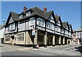
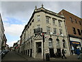
The Queen's Head Hotel, Chesterfield
On the corner of Glumangate and Knifesmithgate. Designed by Wilcockson & Cutts for the Home Brewery. Opened in 1926 as part of the extension of Knifesmithgate as part of the modernisation of the town centre after WW1.
Image: © Alan Murray-Rust
Taken: 15 Jun 2021
0.02 miles
4
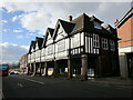
Neo-Tudor on Knifesmithgate, Chesterfield
Chesterfield has several blocks of Neo Tudor buildings in the town centre. Many incorporate colonnaded walks which were a feature of many earlier buildings in the town.
Image: © Jonathan Thacker
Taken: 24 Feb 2023
0.02 miles
5
1 & 3 Knifesmithgate, Chesterfield
Built as part of the extension of Knifesmithgate in 1926, architects Wilcockson & Cutts, for the Home Brewery of Nottingham. The far end was (and is) The Queen's Head Hotel, the nearer end incorporating the car showrooms of Service Motors.
Image: © Alan Murray-Rust
Taken: 15 Jun 2021
0.03 miles
7
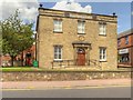
Rose Hill United Reformed Church, Chesterfield
Originally an Independent Chapel, built in 1822, this building is now a United Reformed (Congregational) Church.
See Image]
Image: © David Dixon
Taken: 4 Aug 2014
0.04 miles
8
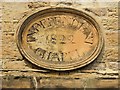
Independent Chapel Plaque
Plaque over the doorway to Image
INDEPENDENT CHAPEL
1822
Image: © David Dixon
Taken: 4 Aug 2014
0.04 miles
9
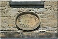
United Reformed Church, Chesterfield ? datestone
See http://www.geograph.org.uk/photo/6885485 for location and details.
Image: © Alan Murray-Rust
Taken: 15 Jun 2021
0.04 miles
10
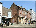
Former Post Office, Market Square, Chesterfield
18th century house which became the Head Post Office in 1886, 3 additional bays being added in the 20th century along with the stone facing of the ground floor, Listed Grade II.
The upper floors have recently (c.2018) been converted from offices to residential apartments, with the ground floor becoming a café bar.
Image: © Alan Murray-Rust
Taken: 15 Jun 2021
0.04 miles