IMAGES TAKEN NEAR TO
Markham Road, CHESTERFIELD, S40 1TG
Introduction
This page details the photographs taken nearby to Markham Road, S40 1TG by members of the Geograph project.
The Geograph project started in 2005 with the aim of publishing, organising and preserving representative images for every square kilometre of Great Britain, Ireland and the Isle of Man.

There are currently over 7.5m images from over14,400 individuals and you can help contribute to the project by visiting https://www.geograph.org.uk
Image Map
Images are licensed for reuse under creativecommons.org/licenses/by-sa/2.0
Notes
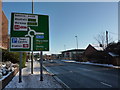
- Clicking on the map will re-center to the selected point.
- The higher the marker number, the further away the image location is from the centre of the postcode.
Image Listing (519 Images Found)
Images are licensed for reuse under creativecommons.org/licenses/by-sa/2.0
Image
Details
Distance
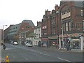
1
Chesterfield - Markham Road and Hipper Street Junction
School on right hand side of picture has now been demolished to make way for Home Furnishing stores.
Image: © Alan Heardman
Taken: 23 Nov 1999
0.02 miles
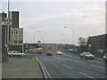
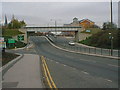
2
Roundabout ahead
Junction of A619, A632 and others
Image: © Peter Barr
Taken: 7 Jan 2010
0.03 miles
3
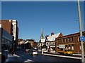
View up St Mary's Gate, Chesterfield
The famous Crooked Spire at the top of the street
Image: © Peter Barr
Taken: 7 Jan 2010
0.03 miles
4
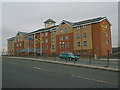
Chesterfield - Ibis Hotel
Originally built as a Holiday Inn.
Image: © Alan Heardman
Taken: 9 Nov 1999
0.03 miles
5
Chesterfield - Beetwell Street
Yeomans Camping Shop in foreground and Police Station in the background.
Image: © Alan Heardman
Taken: 23 Nov 1999
0.04 miles
7
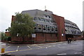
Chesterfield Police Station
On New Beetwell Street.
Image: © Ian S
Taken: 8 Oct 2016
0.06 miles
8
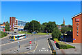
Chesterfield Roundabout
Main road in Chesterfield.
Image: © Wayland Smith
Taken: 17 Jul 2021
0.06 miles
9
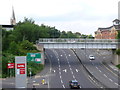
The A617 Chesterfield
This dual carriageway is very close to the centre of the town, In the background can be seen the twisted spire of St Mary's parish church. The bridge across the road used to carry a railway line. To the west (left) part of the old track bed is a walkway. To the east the trackbed comes to a dead end as the bridge that once carried it across Lordsmill St has been totally removed.
Image: © Nigel Mykura
Taken: 19 Jun 2014
0.07 miles
10
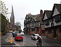
St Mary's Gate, Chesterfield, Derbys.
This is the southern-most section of the B6543 road. A motorcyclist is seen turning into Beetwell Street. St Mary's Church with its well-known "crooked spire" is seen ahead.
Image: © David Hallam-Jones
Taken: 22 Nov 2014
0.07 miles