IMAGES TAKEN NEAR TO
Spring Bank Road, CHESTERFIELD, S40 1NL
Introduction
This page details the photographs taken nearby to Spring Bank Road, S40 1NL by members of the Geograph project.
The Geograph project started in 2005 with the aim of publishing, organising and preserving representative images for every square kilometre of Great Britain, Ireland and the Isle of Man.

There are currently over 7.5m images from over14,400 individuals and you can help contribute to the project by visiting https://www.geograph.org.uk
Image Map
Images are licensed for reuse under creativecommons.org/licenses/by-sa/2.0
Notes
- Clicking on the map will re-center to the selected point.
- The higher the marker number, the further away the image location is from the centre of the postcode.
Image Listing (100 Images Found)
Images are licensed for reuse under creativecommons.org/licenses/by-sa/2.0
Image
Details
Distance
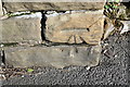
1
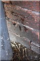
Benchmark on Foljambe Road wall
Ordnance Survey cut mark benchmark levelled at 96.030m above Newlyn Datum in 1961
Image: © Luke Shaw
Taken: 27 Feb 2020
0.04 miles
2
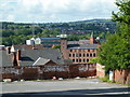
View south from Saltergate Lane, Chesterfield
Looking across the southwestern side of the town.
Image: © Andrew Hill
Taken: 20 Jun 2011
0.04 miles
3
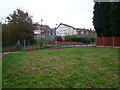
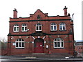
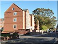
Looking towards Spring Bank Road
The Spring Bank Centre, a hotel and in the far background the eaves of Manor College can be seen.
Image: © Alan Heardman
Taken: 16 Oct 2007
0.05 miles
4
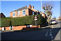
Junction of Springbank Road and Foljambe Road
There is an OS benchmark Image on the brick wall at the corner behind the lamppost
Image: © Luke Shaw
Taken: 27 Feb 2020
0.05 miles
6
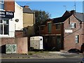
The former premises of Chesterfield Cash Registers Ltd
At the northern [top] end of Foljambe Street.
Image: © Christine Johnstone
Taken: 18 Oct 2018
0.08 miles
8
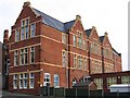
Chesterfield - Goldwell Rooms
This is the only building remaining on the Goldwell Rooms site.
Image: © Dave Bevis
Taken: 30 Nov 2008
0.09 miles
9
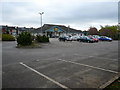
New flats, Fairfield Road, Chesterfield
On the north side of Ashgate Road.
Image: © Christine Johnstone
Taken: 18 Oct 2018
0.09 miles
10
Benchmark on wall opposite #10 Compton Street
Ordnance Survey cut mark benchmark levelled at 106.370m above Newlyn Datum in 1961
Image: © Luke Shaw
Taken: 27 Feb 2020
0.10 miles