IMAGES TAKEN NEAR TO
Oakham Drive, SHEFFIELD, S3 9QX
Introduction
This page details the photographs taken nearby to Oakham Drive, S3 9QX by members of the Geograph project.
The Geograph project started in 2005 with the aim of publishing, organising and preserving representative images for every square kilometre of Great Britain, Ireland and the Isle of Man.

There are currently over 7.5m images from over14,400 individuals and you can help contribute to the project by visiting https://www.geograph.org.uk
Image Map (Loading...)


Getting Data...Please wait
Leaflet Map data © OpenStreetMap
Images are licensed for reuse under creativecommons.org/licenses/by-sa/2.0
Notes
- Clicking on the map will re-center to the selected point.
- The higher the marker number, the further away the image location is from the centre of the postcode.
Image Listing (82 Images Found)
Images are licensed for reuse under creativecommons.org/licenses/by-sa/2.0
Image
Details
Distance
1

Sheffield Ski Centre from Neepsend Lane, Neepsend, Sheffield
The pipe in the foreground is on land just off Neepsend Lane.
Image: © Terry Robinson
Taken: 18 Nov 2008
0.09 miles
2
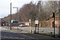
Narrow Road Bridge, Douglas Road, Parkwood Springs, Sheffield
Parkwood Springs was an area of housing in Sheffield, where the majority of men living there - and their families - worked at the Neepsend Railway Station, Train Shed, Carriage Sidings and Goods Depot belonging to the Great Central Railway. The Neepsend Works eventually closed because the similar Works Facilities at Darnall had better road access. The people living in Parkwood Springs moved out of the area and the houses were eventually demolished and replaced by the Sheffield Ski Village! It was this Narrow Road Bridge that was the problem as access to the Works was through here! Image Image
Image: © Terry Robinson
Taken: 18 Nov 2008
0.11 miles
3
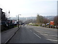
Vale Road, Parkwood Springs, Sheffield
The University Arts Tower is visible in the distance. Many years ago Vale Road and adjoining roads were filled with terraced housing ... now it leads to the Sheffield Ski Village, just out of picture on the left.
Image: © Terry Robinson
Taken: 7 May 2012
0.13 miles
5

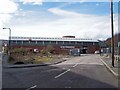
Snow + Rock at the Ski Village, Sheffield
Image: © Terry Robinson
Taken: 18 Nov 2008
0.14 miles
7
Industrial Unit, Manners Street, Neepsend, Sheffield
This building was (I believe) originally used as a Distribution Warehouse for the Cannon Brewery situated just off picture on the left. This picture links with a view of the Brewery Car Park situated on the right ... Image For more details and views of the former Cannon Brewery follow this link ... Image
Image: © Terry Robinson
Taken: 26 Mar 2010
0.15 miles
8
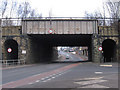
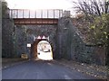
Neepsend - railway bridge over Rutland Road
Image: © Dave Bevis
Taken: 29 Jan 2011
0.16 miles
9
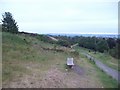
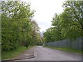
Path and Bench at Parkwood Springs
Looking in the direction of Woodside on a cool and overcast Saturday evening in early June. Note the pair of youngsters dirt-tracking in the middle of shot.
Image: © Jonathan Clitheroe
Taken: 4 Jun 2011
0.16 miles
10
Cannon Brewery Car Park, Manners Street, Neepsend, Sheffield
This picture links on the left with the Industrial Unit ... Image ... The car park was originally for employees at the Cannon Brewery, which is just off picture on the left. The word 'Employees' would imply Office Staff rather than Brewery Workers, who probably used the Tram or 'Bus to get to work!! See also ... Image For more details on the Cannon Brewery see ... Image The banking in the background supports the trackbed of the (former) Great Central Railway, which sounds so much better than British Rail!
Image: © Terry Robinson
Taken: 26 Mar 2010
0.16 miles