IMAGES TAKEN NEAR TO
Rugby Street, SHEFFIELD, S3 9QH
Introduction
This page details the photographs taken nearby to Rugby Street, S3 9QH by members of the Geograph project.
The Geograph project started in 2005 with the aim of publishing, organising and preserving representative images for every square kilometre of Great Britain, Ireland and the Isle of Man.

There are currently over 7.5m images from over14,400 individuals and you can help contribute to the project by visiting https://www.geograph.org.uk
Image Map
Images are licensed for reuse under creativecommons.org/licenses/by-sa/2.0
Notes
- Clicking on the map will re-center to the selected point.
- The higher the marker number, the further away the image location is from the centre of the postcode.
Image Listing (82 Images Found)
Images are licensed for reuse under creativecommons.org/licenses/by-sa/2.0
Image
Details
Distance
1
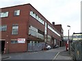
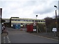
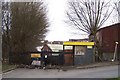
Stanley Tools, Rutland Road Site, Sheffield - 2
This view shows the Woodside Lane entrance, with Rugby Street 'running off' to the left and joining Rutland Road. Image Image Image Image
Image: © Terry Robinson
Taken: 17 Mar 2010
0.01 miles
2
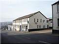
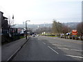
Rutland Road
Rutland Road at the junction of Rugby Lane. The foreground building has since been demolished.
Image: © Martin Speck
Taken: 16 Jul 2007
0.03 miles
3
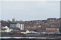
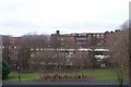
Stanley Tools, Rutland Road Site, Sheffield - 6
This view is taken from Fox Road, Walkely, looking over Neepsend. Follow this link for a closer view and more links ... Image The Tower from Christ Church, Pitsmoor is also clearly visible ... Follow this link for more views ... Image
Image: © Terry Robinson
Taken: 17 Mar 2010
0.05 miles
4
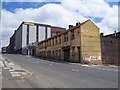
Stanley Tools, Rutland Road Site, Sheffield - 1
This picture shows the main buildings fronting onto Rutland Road ...compare with ... Image ... this later picture does confirm Martin's comments about the demolished properties. Stanley Tools has been in the Sheffield area since 1937 when it took over the Chapman Brace and Drill Factory on Woodside Lane, which runs parallel to and behind Rutland Road. Further sites were opened in Ecclesfield and Hellaby, but in the early 2000s all production was moved to Hellaby. The Ecclesfield site has now been demolished and houses built on the land. This Rutland Road site is empty and becoming more derelict by the day. Image Image Image Image Image
Image: © Terry Robinson
Taken: 19 Mar 2010
0.05 miles
5
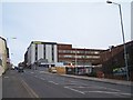
Stanley Tools, Rutland Road Site, Sheffield - 3
This view shows a more modern extension to the original buildings ... looks 1970s to me, so would have been in use for about 25 years. Image Image Image Image
Image: © Terry Robinson
Taken: 17 Mar 2010
0.06 miles
7
Stanley Tools, Rutland Road Site, Sheffield - 4
This view of the rear of the site is taken from Pitsmoor Road, and gives another view of the more modern extension. Image Image Image Image
Image: © Terry Robinson
Taken: 28 Feb 2010
0.06 miles
10
Stanley Tools, Rutland Road Site, Sheffield - 5
This view shows the original Woodfold Entrance ... long closed and looking very poor with loads of rubbish all around the site. Shame as many local and not so local people would have used this entrance and have had good memories - and probably not so good - of working here. The dereliction surely sours these memories. Image Image Image Image
Image: © Terry Robinson
Taken: 17 Mar 2010
0.13 miles