IMAGES TAKEN NEAR TO
Brunswick Road, SHEFFIELD, S3 9LR
Introduction
This page details the photographs taken nearby to Brunswick Road, S3 9LR by members of the Geograph project.
The Geograph project started in 2005 with the aim of publishing, organising and preserving representative images for every square kilometre of Great Britain, Ireland and the Isle of Man.

There are currently over 7.5m images from over14,400 individuals and you can help contribute to the project by visiting https://www.geograph.org.uk
Image Map
Images are licensed for reuse under creativecommons.org/licenses/by-sa/2.0
Notes
- Clicking on the map will re-center to the selected point.
- The higher the marker number, the further away the image location is from the centre of the postcode.
Image Listing (83 Images Found)
Images are licensed for reuse under creativecommons.org/licenses/by-sa/2.0
Image
Details
Distance
2
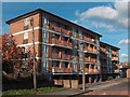
Spital Lane Flats, Burngreave, Sheffield
Image: © Neil Theasby
Taken: 6 Nov 2010
0.07 miles
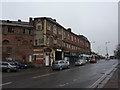
3
Spital Hill - "The East House" public house
Image: © Neil Theasby
Taken: 6 Nov 2010
0.08 miles
5
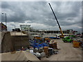
Yes, you guessed it, another Tesco
About to spring up in Burngreave, at the junction of Spital Hill and Saville Street, another branch of the third largest retailer in the world.
Image: © Peter Barr
Taken: 13 Jul 2011
0.13 miles
6
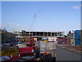
Tesco building site
The Spital Hill Tesco Extra under construction. The store occupies what was once the site of Sheffield's first railway station.
Image: © Martin Speck
Taken: 29 May 2011
0.15 miles
7
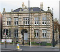
Vestry Hall, Burngreave
Built in 1864 to accommodate the Brightside Bierlow Vestry which was the organisation responsible for administering the Poor Law in this part of Sheffield. Bierlow is a local word meaning ward or township.
Image: © David Rogers
Taken: 26 Oct 2009
0.15 miles
8
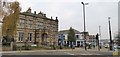
Vestry Hall, Burngreave
The Vestry Hall offices were built in 1846 for the Brightside Bierlow Vestry, the organisation responsible for administering the Poor Law in this part of Sheffield.
Image: © Chris Morgan
Taken: 21 Nov 2019
0.16 miles
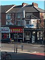
9
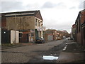
Sorby Street
A mixture of workshops and derelict sites. Note the roadway of setts, typical of this part of the city.
Image: © Jonathan Thacker
Taken: 15 Dec 2012
0.16 miles
