IMAGES TAKEN NEAR TO
Lopham Street, SHEFFIELD, S3 9JT
Introduction
This page details the photographs taken nearby to Lopham Street, S3 9JT by members of the Geograph project.
The Geograph project started in 2005 with the aim of publishing, organising and preserving representative images for every square kilometre of Great Britain, Ireland and the Isle of Man.

There are currently over 7.5m images from over14,400 individuals and you can help contribute to the project by visiting https://www.geograph.org.uk
Image Map
Images are licensed for reuse under creativecommons.org/licenses/by-sa/2.0
Notes
- Clicking on the map will re-center to the selected point.
- The higher the marker number, the further away the image location is from the centre of the postcode.
Image Listing (37 Images Found)
Images are licensed for reuse under creativecommons.org/licenses/by-sa/2.0
Image
Details
Distance
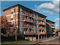
2

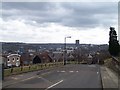
View towards Burngreave and Pye Bank School
New developments close to the Inner Ring Road with Pye Bank School on the hilltop beyond.
Image: © Jonathan Thacker
Taken: 15 Dec 2012
0.09 miles
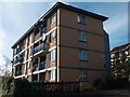
4
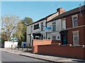
Spital Lane Flats, Burngreave, Sheffield
Image: © Neil Theasby
Taken: 6 Nov 2010
0.15 miles
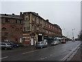
5
Spital Hill - "The East House" public house
Image: © Neil Theasby
Taken: 6 Nov 2010
0.18 miles

8
Gray Street, Woodside, Sheffield
Now devoid of housing, but back in the 1970s the whole area was built-up with houses just like the one on the left with the semi-circular roof. At that date these houses would have been thought of as 'cutting edge' design. A row of these houses still exists in Pye Bank Road, see ... Image ... The view over Sheffield City Centre will always have been fantastic, but in the 1970s wouldn't have included a Big Wheel or a huge Tower Block! On the right of the tree is Andover Street which is also in the same sorry condition, see ... Image
Image: © Terry Robinson
Taken: 17 Mar 2010
0.20 miles
9
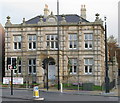
Vestry Hall, Burngreave
Built in 1864 to accommodate the Brightside Bierlow Vestry which was the organisation responsible for administering the Poor Law in this part of Sheffield. Bierlow is a local word meaning ward or township.
Image: © David Rogers
Taken: 26 Oct 2009
0.20 miles
10
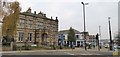
Vestry Hall, Burngreave
The Vestry Hall offices were built in 1846 for the Brightside Bierlow Vestry, the organisation responsible for administering the Poor Law in this part of Sheffield.
Image: © Chris Morgan
Taken: 21 Nov 2019
0.20 miles