IMAGES TAKEN NEAR TO
Millsands, SHEFFIELD, S3 8DT
Introduction
This page details the photographs taken nearby to Millsands, S3 8DT by members of the Geograph project.
The Geograph project started in 2005 with the aim of publishing, organising and preserving representative images for every square kilometre of Great Britain, Ireland and the Isle of Man.

There are currently over 7.5m images from over14,400 individuals and you can help contribute to the project by visiting https://www.geograph.org.uk
Image Map (Loading...)


Getting Data...Please wait
Leaflet Map data © OpenStreetMap
Images are licensed for reuse under creativecommons.org/licenses/by-sa/2.0
Notes
- Clicking on the map will re-center to the selected point.
- The higher the marker number, the further away the image location is from the centre of the postcode.
Image Listing (919 Images Found)
Images are licensed for reuse under creativecommons.org/licenses/by-sa/2.0
Image
Details
Distance
1
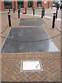
1780s Cementation furnace
In 1999, outside the new Irwin Mitchell Building, archaeologists uncovered the fire hearth and flue of a 1780s cementation furnace. The glass pavement allows a view of the 18th.Century brickwork and rough sandstone beneath.
Image: © Dave Pickersgill
Taken: 9 May 2012
0.02 miles
2
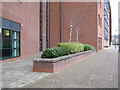
Planter behind solicitor's offices
It takes courage to plant fancy birch trees in north-facing permanent shade. Keep an eye on them, Sheffield. Many sizeable new buildings front this walk beside the River Don.
Image: © Robin Stott
Taken: 3 Apr 2012
0.02 miles
3
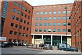
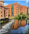
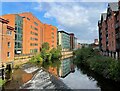
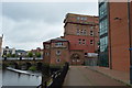
Riverside East
Urban redevelopment on the banks of the R. Don, Sheffield
Image: © N Chadwick
Taken: 26 Apr 2008
0.02 miles
4
Riverside development at Wicker Weir on a winter evening
Image: © Graham Hogg
Taken: 25 Nov 2022
0.02 miles
6
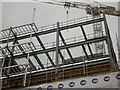
Steel frame to new riverside apartments.
Image: © Steve Fareham
Taken: 5 Jun 2004
0.03 miles
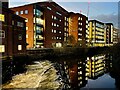
7
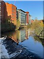
Riverside development above Wicker Weir
This weir on the River Don in the city centre is so close to the start of the Five Weirs Walk perhaps it should be incorporated into a re-named Walk?
For a similar view later on the same day see Image
Image: © Graham Hogg
Taken: 25 Nov 2022
0.03 miles
10
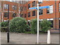
Cycle route sign
The sign, on Bridge Street, points to the hospital in one direction, and to Kelham Island in the other. Fortunately I was on my way to the latter, for a Geograph pre-conference social gathering.
Image: © Stephen Craven
Taken: 3 Apr 2012
0.04 miles