IMAGES TAKEN NEAR TO
St. Georges Close, SHEFFIELD, S3 7HJ
Introduction
This page details the photographs taken nearby to St. Georges Close, S3 7HJ by members of the Geograph project.
The Geograph project started in 2005 with the aim of publishing, organising and preserving representative images for every square kilometre of Great Britain, Ireland and the Isle of Man.

There are currently over 7.5m images from over14,400 individuals and you can help contribute to the project by visiting https://www.geograph.org.uk
Image Map
Images are licensed for reuse under creativecommons.org/licenses/by-sa/2.0
Notes
- Clicking on the map will re-center to the selected point.
- The higher the marker number, the further away the image location is from the centre of the postcode.
Image Listing (661 Images Found)
Images are licensed for reuse under creativecommons.org/licenses/by-sa/2.0
Image
Details
Distance
1
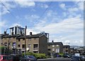
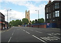
Housing on St George's Close, Netherthorpe, Sheffield - 1
Looking down hill towards Shalesmoor
The Blue and White Tower is one of the Netherthorpe Blocks
The Brown and White Tower, at the bottom of the road, is one
of Upperthorpe Blocks
See also …
Image
Image: © Terry Robinson
Taken: 14 Aug 2012
0.02 miles
2
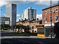
Brook Hill, Sheffield on a Sunday afternoon
Looking towards The Arts Tower
Image: © Neil Theasby
Taken: 2 Oct 2016
0.03 miles
5
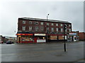
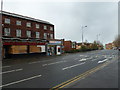
Sheffield - S1 (City Centre)
A view of the city-bound A57 road with the remnants of the Jessop Hospital for Women and the former St George's Church (now a university lecture theatre) on the right. In amongst the parade of shops on the left is a restaurant named Butler's Balti House that was formerly a city-renowned greasy-spoon cafe called "Butler's" that served the local working population. The Henderson's Relish factory is still functioning nearby, behind this Jessop Hospital remnant.
Image: © David Hallam-Jones
Taken: 3 Jun 2012
0.04 miles
7
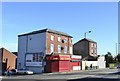
Shops on Brook Hill, Sheffield
Originally there were five shops … numbers 3 and 4 have been demolished.
Image: © Terry Robinson
Taken: 24 Oct 2013
0.04 miles
8
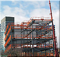
Student accommodation
In background arts tower Sheffield university. Steel frame by Robinson of Derby, edge protection by easi-edge.
Image: © Steve Fareham
Taken: 30 Mar 2006
0.04 miles
9
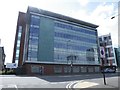
Sheffield Bioincubator, Brook Hill, Sheffield
The Sheffield Bioincubator is an Office and Laboratory
complex, owned and run by University of Sheffield Innovation.
It opened in 2006 and offers Office and Laboratory
facilities to small and medium technology businesses.
See also …
Image
Image
Image
Image: © Terry Robinson
Taken: 14 Aug 2012
0.04 miles
10
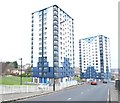
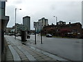
Netherthorpe, Sheffield
The demolition of Victorian terraced housing in Netherthorpe began in 1956 as part of the redevelopment of an area of 48.5 hectares and new council owned dwellings were constructed in phases between 1959-1972. These included four tower blocks that were completed in 1962, these two being named Robertshaw and Crawshaw. All four were re-clad in a blue and cream colour scheme, and improved, in 1998. This dual carriageway, together with a central section of tram tracks, links University Square roundabout (behind the photographer) with Infirmary Road.
Image: © David Hallam-Jones
Taken: 19 Feb 2018
0.04 miles