IMAGES TAKEN NEAR TO
Bolsterstone, SHEFFIELD, S36 4ZA
Introduction
This page details the photographs taken nearby to S36 4ZA by members of the Geograph project.
The Geograph project started in 2005 with the aim of publishing, organising and preserving representative images for every square kilometre of Great Britain, Ireland and the Isle of Man.

There are currently over 7.5m images from over14,400 individuals and you can help contribute to the project by visiting https://www.geograph.org.uk
Image Map
Images are licensed for reuse under creativecommons.org/licenses/by-sa/2.0
Notes
- Clicking on the map will re-center to the selected point.
- The higher the marker number, the further away the image location is from the centre of the postcode.
Image Listing (14 Images Found)
Images are licensed for reuse under creativecommons.org/licenses/by-sa/2.0
Image
Details
Distance
1

Dwarriden
Smallholding at Swarriden.
Image: © Peter McDermott
Taken: 11 Apr 2015
0.00 miles
2
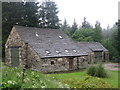
Dwarriden Cruck Barn
The Grade II listed, Dwarriden Cruck Barn which was built ~1600. It was restored in 1994.
Image: © Dave Pickersgill
Taken: 21 Jun 2012
0.01 miles
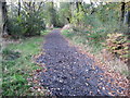
4

Right turn to Canyards
Alongside Broomhead reservoir.
Image: © Steve Fareham
Taken: 24 Oct 2008
0.14 miles
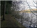
5
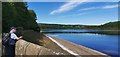
Broomhead Reservoir
Broomhead Reservoir, as seen from Heads lane, Bolsterstone.
Image: © Dave Pickersgill
Taken: 8 Oct 2013
0.14 miles
8
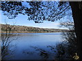
Broomhead reservoir.
In the Ewden valley.
Image: © steven ruffles
Taken: 6 Apr 2015
0.20 miles
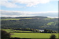
9
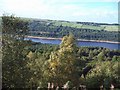
Broomhead Reservoir viewed from Walker Edge
Image: © Jonathan Clitheroe
Taken: 12 Sep 2010
0.24 miles