IMAGES TAKEN NEAR TO
Manchester Road, SHEFFIELD, S36 2DS
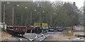
Introduction
This page details the photographs taken nearby to Manchester Road, S36 2DS by members of the Geograph project.
The Geograph project started in 2005 with the aim of publishing, organising and preserving representative images for every square kilometre of Great Britain, Ireland and the Isle of Man.

There are currently over 7.5m images from over14,400 individuals and you can help contribute to the project by visiting https://www.geograph.org.uk
Image Map
Images are licensed for reuse under creativecommons.org/licenses/by-sa/2.0
Notes
- Clicking on the map will re-center to the selected point.
- The higher the marker number, the further away the image location is from the centre of the postcode.
Image Listing (136 Images Found)
Images are licensed for reuse under creativecommons.org/licenses/by-sa/2.0
Image
Details
Distance
1
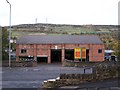
Gordon's Auto Centre, Manchester Road, Stocksbridge
This Auto Centre is also a neighbour of St Matthias' Church ... it replaced an earlier row of terraced houses.
Image: © Terry Robinson
Taken: 7 Nov 2008
0.01 miles
2

The Stocksbridge railway
The railway line from Sheffield having arrived within the confines of the steelworks - perhaps one day this line will be a passenger line to Manchester??
Image: © Dave Pickersgill
Taken: 19 Apr 2009
0.01 miles
3
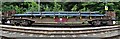
Stationary goods train at Fox Valley
Image: © Dave Pickersgill
Taken: 21 Jul 2020
0.02 miles
4
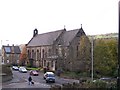
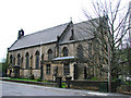
St Matthias' Church, Stocksbridge
This church was built in 1890 as a memorial to Samuel Fox, founder of the Steelworks in the town. As seen in the picture ... next door to this fabulous Church is ... the not so fabulous, Solar Panelled Town Hall (complete with modern extension)! Image
Image: © Terry Robinson
Taken: 7 Nov 2008
0.04 miles
5
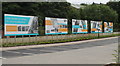
The Story of Steel
'The Story of Steel,' as displayed at Fox Valley, the new retail development in Stocksbridge.
Image: © Dave Pickersgill
Taken: 17 Jun 2016
0.05 miles
6
Stocksbridge railway
Rolling stock and rail track at the steelworks in the centre of Stocksbridge - looks ready to be transformed into a passenger line!
Image: © Dave Pickersgill
Taken: 17 Dec 2012
0.05 miles
8

Bus stop on Manchester Road (B6088), Stocksbridge
Looking south east.
Image: © JThomas
Taken: 21 Mar 2019
0.05 miles
9
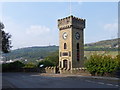
Stocksbridge Clock Tower
Built in 1923 to commemorate the local people who had given their lives in the 1914-18 war. http://www.stocksbridge-council.co.uk/clock_tower_gardens.htm
Image: © Graham Hogg
Taken: 5 Sep 2014
0.05 miles
10
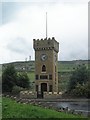
Stocksbridge Clock Tower
The Clock Tower was completed in 1923 as a Memorial to the 106 Men and 1 Woman, from Stocksbridge, who lost their lives during The Great War (WW1). The names of the 51 who lost their lives in WW2 were also added. The Tower is at the top of the Clock Tower Gardens and, not surprisingly there are great views over the Stocksbridge Valley and Hunshelf Bank opposite ... including that Communications Aerial! Image Image Image
Image: © Terry Robinson
Taken: 30 Apr 2008
0.05 miles