IMAGES TAKEN NEAR TO
Hunshelf Bank, SHEFFIELD, S36 2BS
Introduction
This page details the photographs taken nearby to Hunshelf Bank, S36 2BS by members of the Geograph project.
The Geograph project started in 2005 with the aim of publishing, organising and preserving representative images for every square kilometre of Great Britain, Ireland and the Isle of Man.

There are currently over 7.5m images from over14,400 individuals and you can help contribute to the project by visiting https://www.geograph.org.uk
Image Map
Images are licensed for reuse under creativecommons.org/licenses/by-sa/2.0
Notes
- Clicking on the map will re-center to the selected point.
- The higher the marker number, the further away the image location is from the centre of the postcode.
Image Listing (17 Images Found)
Images are licensed for reuse under creativecommons.org/licenses/by-sa/2.0
Image
Details
Distance
1
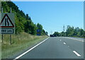
A616 Stocksbridge Bypass near Crimbles Farm
Image: © Colin Pyle
Taken: 10 Jul 2022
0.10 miles
2
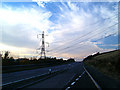
Stocksbridge bypass
Criss crossed with power cables serving the Corus plant no doubt.
Image: © Steve Fareham
Taken: 4 Nov 2007
0.11 miles
3
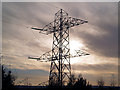
Who's got their wires crossed?
High voltage electricity cables and pylons on Hunshelf Bank
Image: © Graham Hogg
Taken: 21 Mar 2016
0.11 miles
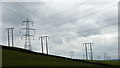
4
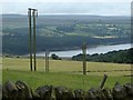
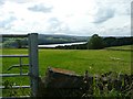
Fields and valley view
Despite the many power lines, the views are good from this stretch of the Barnsley Boundary Walk. Looking down to Underbank Reservoir.
Image: © Andrew Hill
Taken: 31 Jul 2013
0.17 miles
5
Mucky Lane
Along the Barnsley Boundary Walk.
Image: © steven ruffles
Taken: 28 Feb 2012
0.17 miles
6
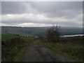
Mucky Lane
On the Barnsley Boundary Walk. Underbank Reservoir in the distance
Image: © John Slater
Taken: 29 Feb 2012
0.17 miles
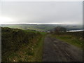
7
Mucky Lane, downhill view
Looking down the track and across the valley.
Image: © Andrew Hill
Taken: 31 Jul 2013
0.17 miles
8
View towards Underbank Reservoir
We should now be on the Barnsley Boundary Walk but didn't see a waymark sign all afternoon. We were also on the edge of our OS map which didn't help. See previous Geograph: Image
Image: © Wendy North
Taken: 13 Aug 2008
0.18 miles
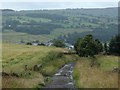
9
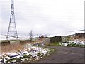
Mucky Lane
Quaintly named country track leading from this point near Horsley House, up over the hill to emerge by the electricity substation at Hunshelf.
Image: © Roger May
Taken: 25 Feb 2006
0.19 miles