IMAGES TAKEN NEAR TO
Brooke Close, SHEFFIELD, S36 2AH
Introduction
This page details the photographs taken nearby to Brooke Close, S36 2AH by members of the Geograph project.
The Geograph project started in 2005 with the aim of publishing, organising and preserving representative images for every square kilometre of Great Britain, Ireland and the Isle of Man.

There are currently over 7.5m images from over14,400 individuals and you can help contribute to the project by visiting https://www.geograph.org.uk
Image Map
Images are licensed for reuse under creativecommons.org/licenses/by-sa/2.0
Notes
- Clicking on the map will re-center to the selected point.
- The higher the marker number, the further away the image location is from the centre of the postcode.
Image Listing (95 Images Found)
Images are licensed for reuse under creativecommons.org/licenses/by-sa/2.0
Image
Details
Distance
1
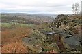
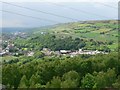
Stocksbridge and Deepcar
Stocksbridge and Deepcar seen from Wharncliffe Crags.
Image: © Dave Pickersgill
Taken: 28 Nov 2013
0.01 miles
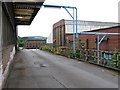
3
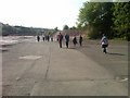
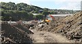
Ex-steel works
Walking across the site of (now demolished) steel works in Stocksbridge. This photograph was taken on the first walk of the 'Stocksbridge Welcome to Walkers' initiative.
Image: © Dave Pickersgill
Taken: 30 Apr 2011
0.02 miles
4
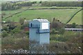
Stocksbridge's Second Tower
This tower is a monument to the Steelworks! ... well it's part of the Steelworks anyway. Image
Image: © Terry Robinson
Taken: 30 Apr 2008
0.05 miles
5
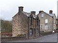
'Lonely' House in Stocksbridge
From the look of the lower windows this house may have been a shop at one time. The 1903 Stocksbridge map shows a terrace of houses on the nearside of this house. Update on 15th November 2008 ... I have now seen a photograph of this area, dated 1910, and the terrace of (eight) houses is clearly visible. The subject house certainly looks (on the photo) to be either a shop or possibly a pub.
Image: © Terry Robinson
Taken: 30 Apr 2008
0.06 miles
6
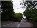
Manchester Road at the junction of New Road
Image: © Martin Speck
Taken: 11 Aug 2010
0.07 miles
7
View across the valley of the Little Don at Deepcar
This view taken from Wharncliffe Crags shows parts of Deepcar, the A616 Stocksbridge bypass and Hunshelf Bank. As I walk around the area I'm trying to connect the present day landscape with that of the past. Along the route of the A616 were the Hen Holmes Works, one of the largest Gannister concerns in Deepcar. (Owned and developed by John Armitage.) Further along Hunshelf bank White Carr clay was mined. (See Battye, Ray ( 2004), The forgotten Mines of Sheffield)
Image: © Wendy North
Taken: 31 May 2007
0.07 miles
8
Fox Valley Development, Stocksbridge
Image: © Dave Pickersgill
Taken: 24 Sep 2015
0.08 miles
9
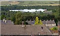
Rooftops and steelworks
Part of the large Tata steelworks at Stocksbridge which occupy a large site in the floor of the Little Don Valley
Image: © Graham Hogg
Taken: 5 Sep 2014
0.08 miles
10

Bus stop on Manchester Road (B6088), Stocksbridge
Looking south east.
Image: © JThomas
Taken: 21 Mar 2019
0.09 miles