IMAGES TAKEN NEAR TO
Hole House Lane, SHEFFIELD, S36 1BP
Introduction
This page details the photographs taken nearby to Hole House Lane, S36 1BP by members of the Geograph project.
The Geograph project started in 2005 with the aim of publishing, organising and preserving representative images for every square kilometre of Great Britain, Ireland and the Isle of Man.

There are currently over 7.5m images from over14,400 individuals and you can help contribute to the project by visiting https://www.geograph.org.uk
Image Map (Loading...)


Getting Data...Please wait
Leaflet Map data © OpenStreetMap
Images are licensed for reuse under creativecommons.org/licenses/by-sa/2.0
Notes
- Clicking on the map will re-center to the selected point.
- The higher the marker number, the further away the image location is from the centre of the postcode.
Image Listing (125 Images Found)
Images are licensed for reuse under creativecommons.org/licenses/by-sa/2.0
Image
Details
Distance
1
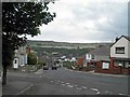
Stocksbridge from Whitwell Crescent
In the valley is TATA steelworks.
Image: © Steve Fareham
Taken: 10 Jul 2011
0.01 miles
4
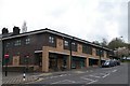
Valley Medical Centre, Johnson Street, Stocksbridge - 1
This building is on various levels ... the single storey GP's part is further up the street ... see ...
Image
Image: © Terry Robinson
Taken: 30 Apr 2008
0.05 miles
5
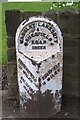
Milestone on Manchester Road, Stocksbridge
It might be on Manchester Road but the mileages shown are for Sheffield, Huddersfield and Holmfirth ... For Manchester you follow the road towards Huddersfield and turn left at The Flouch Inn!
Image: © Terry Robinson
Taken: 30 Apr 2008
0.05 miles
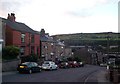
6

Re-Cycling and Modern Dry-Stone Walling in Stocksbridge
Image: © Terry Robinson
Taken: 30 Apr 2008
0.05 miles
7

Steps to Coronation Road, Stocksbridge
These steps lead up from Manchester Road to the Coronation Road area of Stocksbridge
Image: © Terry Robinson
Taken: 6 May 2013
0.06 miles
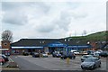
8
Industrial and Retail
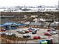
From a vantage point on Edward Street at Snowden Hill, one can look across the carpark of a local superstore to see part of the extensive steelworks at Stocksbridge. The slopes on the opposite side of the valley sweep down from Hunshelf. The main street, Manchester Road, runs between the two horizontally across the shot. Until the construction of the A616 bypass, which runs parallel behind the trees, Manchester road used to be the main trunk road - causing a huge bottleneck through the village.
Image: © Roger May
Taken: 25 Feb 2006
0.06 miles
9
Snow in Spring!
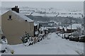
The view looking down Rundle Road at noon on the 23rd.March 2013. Unseasonal snow is creating a very wintry scene.
Image: © Dave Pickersgill
Taken: 23 Mar 2013
0.06 miles
10
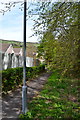
Footpath to Manchester Road, Horner House, Stocksbridge
Image: © Terry Robinson
Taken: 6 May 2013
0.07 miles