IMAGES TAKEN NEAR TO
Top Side, SHEFFIELD, S35 8RD
Introduction
This page details the photographs taken nearby to Top Side, S35 8RD by members of the Geograph project.
The Geograph project started in 2005 with the aim of publishing, organising and preserving representative images for every square kilometre of Great Britain, Ireland and the Isle of Man.

There are currently over 7.5m images from over14,400 individuals and you can help contribute to the project by visiting https://www.geograph.org.uk
Image Map
Images are licensed for reuse under creativecommons.org/licenses/by-sa/2.0
Notes
- Clicking on the map will re-center to the selected point.
- The higher the marker number, the further away the image location is from the centre of the postcode.
Image Listing (41 Images Found)
Images are licensed for reuse under creativecommons.org/licenses/by-sa/2.0
Image
Details
Distance

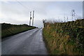
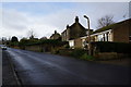
2
Trans Pennine Trail route, Grenoside
Near entrance to Wheata Wood.
Image: © Peter Barr
Taken: 5 Oct 2011
0.06 miles

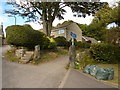
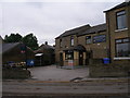
4

Arriving at Grenoside from Wheata Wood
Part of the Trans-Pennine Trail
Image: © John Slater
Taken: 11 Jun 2012
0.09 miles
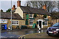
8
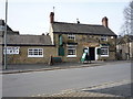
The Old Harrow Inn, Grenoside
On Main Street.
Image: © JThomas
Taken: 12 Mar 2016
0.15 miles