IMAGES TAKEN NEAR TO
Rocher Grove, SHEFFIELD, S35 8QQ
Introduction
This page details the photographs taken nearby to Rocher Grove, S35 8QQ by members of the Geograph project.
The Geograph project started in 2005 with the aim of publishing, organising and preserving representative images for every square kilometre of Great Britain, Ireland and the Isle of Man.

There are currently over 7.5m images from over14,400 individuals and you can help contribute to the project by visiting https://www.geograph.org.uk
Image Map
Images are licensed for reuse under creativecommons.org/licenses/by-sa/2.0
Notes
- Clicking on the map will re-center to the selected point.
- The higher the marker number, the further away the image location is from the centre of the postcode.
Image Listing (6 Images Found)
Images are licensed for reuse under creativecommons.org/licenses/by-sa/2.0
Image
Details
Distance
3
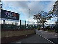
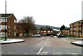
Entrance to Yewlands Technology College
On Creswick Lane, between Parson Cross and Grenoside.
Image: © Peter Barr
Taken: 5 Oct 2011
0.20 miles
4
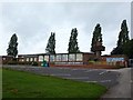
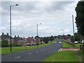
St. Thomas More School
A Catholic primary school for children aged 4-11.
Image: © Graham Hogg
Taken: 14 Aug 2012
0.22 miles