IMAGES TAKEN NEAR TO
Penistone Road, SHEFFIELD, S35 8QG
Introduction
This page details the photographs taken nearby to Penistone Road, S35 8QG by members of the Geograph project.
The Geograph project started in 2005 with the aim of publishing, organising and preserving representative images for every square kilometre of Great Britain, Ireland and the Isle of Man.

There are currently over 7.5m images from over14,400 individuals and you can help contribute to the project by visiting https://www.geograph.org.uk
Image Map
Images are licensed for reuse under creativecommons.org/licenses/by-sa/2.0
Notes
- Clicking on the map will re-center to the selected point.
- The higher the marker number, the further away the image location is from the centre of the postcode.
Image Listing (30 Images Found)
Images are licensed for reuse under creativecommons.org/licenses/by-sa/2.0
Image
Details
Distance
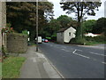
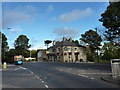
3
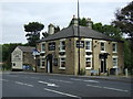
The Norfolk Arms, Grenoside
On Penistone Road.
Image: © JThomas
Taken: 27 Sep 2014
0.03 miles
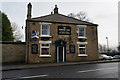
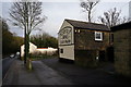
7
Norfolk Arms, to let
Pub on Penistone Road, Grenoside, for which a new landlord is required.
Image: © Peter Barr
Taken: 5 Oct 2011
0.03 miles
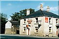
8
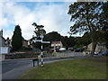
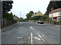
Penistone Road at Grenoside
The road opposite is Norfolk Hill.The "pre-Worboys" sign , named Grenoside, Yorks W.R., and numbered 336942, points to Burncross and Ecclesfield.
Image: © Peter Barr
Taken: 5 Oct 2011
0.03 miles