IMAGES TAKEN NEAR TO
South Road, SHEFFIELD, S35 4JL
Introduction
This page details the photographs taken nearby to South Road, S35 4JL by members of the Geograph project.
The Geograph project started in 2005 with the aim of publishing, organising and preserving representative images for every square kilometre of Great Britain, Ireland and the Isle of Man.

There are currently over 7.5m images from over14,400 individuals and you can help contribute to the project by visiting https://www.geograph.org.uk
Image Map
Images are licensed for reuse under creativecommons.org/licenses/by-sa/2.0
Notes
- Clicking on the map will re-center to the selected point.
- The higher the marker number, the further away the image location is from the centre of the postcode.
Image Listing (23 Images Found)
Images are licensed for reuse under creativecommons.org/licenses/by-sa/2.0
Image
Details
Distance
1
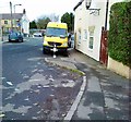
Fish and chip shop, The Circle, High Green
Image: © Neil Theasby
Taken: 19 Dec 2012
0.03 miles
3
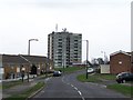
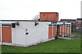
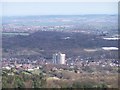
The Fosters Tower Block, Angram Bank, High Green - 1 (April 2010)
The Fosters Tower Block, built in the mid 1960s, is a ten storey block of two bedroom flats. Initially there were retail units and a caretaker’s flat on the ground floor. At a later date telecommunication aerials were erected on the roof. Refurbishment work on the flats and the surrounding area started early in 2010. The Angram Bank estate - where the Tower Block is located - was built on the site of the former WW2 Potter Hill Army Camp ... later converted to and used as POW Camp. Allegedly, for years afterwards local people living on the estate referred to it as the camp site. For more images, see ... Image ... Image ... Image ... Image ... By September 2011 all refurbishment work on the Tower Block had ceased and demolition was taking place, see ... Image ... Image ... Image
Image: © Terry Robinson
Taken: 14 Apr 2010
0.14 miles
4
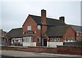
"The Phoenix" public house at High Green
Image: © Neil Theasby
Taken: 19 Dec 2012
0.15 miles
5
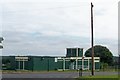
Community Centre and TARA, Angram Bank, High Green - September 2010
See also ... Image
Image: © Terry Robinson
Taken: 4 Sep 2010
0.15 miles
6
Community Centre and TARA, Angram Bank, High Green - April 2010
The Community Centre and TARA (Tenants and Residents Association) is in the pink! But not for long ... Image
Image: © Terry Robinson
Taken: 14 Apr 2010
0.17 miles
7
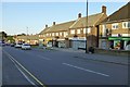
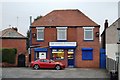
Row of shops
On Greengate Lane, High Green
Image: © David Lally
Taken: 17 Sep 2016
0.17 miles
8
The Fosters Tower Block, from Woodhead Road, near Grenoside
Image: © Terry Robinson
Taken: 11 Apr 2010
0.18 miles
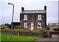
9
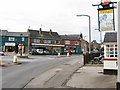
High Green Post Office
The post office at Mortomley stands opposite the Old Cart and Horses public house, just off the roundabout.
Image: © Roger May
Taken: 13 Mar 2006
0.19 miles