IMAGES TAKEN NEAR TO
Coppice Rise, SHEFFIELD, S35 2YZ
Introduction
This page details the photographs taken nearby to Coppice Rise, S35 2YZ by members of the Geograph project.
The Geograph project started in 2005 with the aim of publishing, organising and preserving representative images for every square kilometre of Great Britain, Ireland and the Isle of Man.

There are currently over 7.5m images from over14,400 individuals and you can help contribute to the project by visiting https://www.geograph.org.uk
Image Map
Images are licensed for reuse under creativecommons.org/licenses/by-sa/2.0
Notes
- Clicking on the map will re-center to the selected point.
- The higher the marker number, the further away the image location is from the centre of the postcode.
Image Listing (20 Images Found)
Images are licensed for reuse under creativecommons.org/licenses/by-sa/2.0
Image
Details
Distance
1
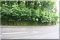
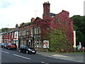
Ivy-clad White Lane wall at junction with Station Road
There is an OS benchmark Image on the wall near the left hand side of the image
Image: © Roger Templeman
Taken: 21 Jun 2013
0.06 miles
2
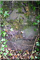
Benchmark on ivy-clad wall of White Lane
Ordnance Survey cut mark benchmark described on the Bench Mark Database at http://www.bench-marks.org.uk/bm49363
Image: © Roger Templeman
Taken: 21 Jun 2013
0.06 miles
3
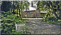
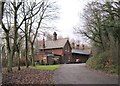
Former Chapeltown & Thorncliffe (later Central) station
View NW, towards Barnsley: ex-GC Sheffield Victoria - Barnsley line. The station (named 'Central' from 18/6/51) was closed when the passenger service ceased on 7/12/53, but was open for goods until 1/4/55 and the line remained until 3/66. Clearly, by 1998 it was a flourishing private house. The whole area of South Yorkshire was honeycombed with railways as long as the coal mines flourished.
Image: © Ben Brooksbank
Taken: 21 Jun 1998
0.06 miles
4
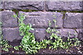
Benchmark on Station Road river bridge
Ordnance Survey cut mark benchmark described on the Bench Mark Database at http://www.bench-marks.org.uk/bm49362
Image: © Roger Templeman
Taken: 21 Jun 2013
0.08 miles
5
Bridge taking A6135 over Blackburn Brook
There is an OS benchmark Image on the bridge parapet
Image: © Roger Templeman
Taken: 21 Jun 2013
0.08 miles
7
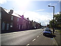
Chapeltown Central railway station (site), Yorkshire
Also known as Chapeltown & Thorncliffe, this station was opened in 1853 by the South Yorkshire Railway on the line from Sheffield Victoria to Barnsley (Stairfoot) via the Blackburn Valley, and closed to passengers in 1954. View up the approach road.
Image: © Nigel Thompson
Taken: 17 Dec 2009
0.11 miles
9
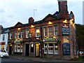
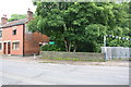
Journey's end at The Commercial
A welcome sight at the end of this day's 12 mile geographing walk!
Image: © Graham Hogg
Taken: 18 Nov 2011
0.14 miles
10
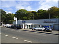
The Commercial pub, Chapeltown
On Station Road.
Image: © JThomas
Taken: 27 Sep 2014
0.15 miles