IMAGES TAKEN NEAR TO
Avon Grove, SHEFFIELD, S35 2XU
Introduction
This page details the photographs taken nearby to Avon Grove, S35 2XU by members of the Geograph project.
The Geograph project started in 2005 with the aim of publishing, organising and preserving representative images for every square kilometre of Great Britain, Ireland and the Isle of Man.

There are currently over 7.5m images from over14,400 individuals and you can help contribute to the project by visiting https://www.geograph.org.uk
Image Map
Images are licensed for reuse under creativecommons.org/licenses/by-sa/2.0
Notes
- Clicking on the map will re-center to the selected point.
- The higher the marker number, the further away the image location is from the centre of the postcode.
Image Listing (19 Images Found)
Images are licensed for reuse under creativecommons.org/licenses/by-sa/2.0
Image
Details
Distance
3
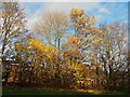
Autumn colour in Charlton Brook
Charlton Brook provides a ribbon of green space in the middle of a large housing development
Image: © Graham Hogg
Taken: 23 Nov 2020
0.10 miles
4

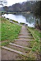
Forlorn swings in Charltonbrook Park
At High Green, Sheffield
Image: © Neil Theasby
Taken: 19 Dec 2012
0.11 miles
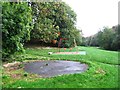
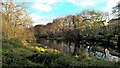
5
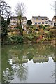
Looking across Charltonbrook Dam
At High Green, Sheffield
Image: © Neil Theasby
Taken: 19 Dec 2012
0.12 miles
6
Charltonbrook Dam, High Green, Sheffield
Image: © Neil Theasby
Taken: 19 Dec 2012
0.14 miles
7
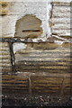
Benchmark on #365 Burncross Road, Wharncliffe Arms
Ordnance Survey cut mark benchmark described on the Bench Mark Database at http://www.bench-marks.org.uk/bm49374
Image: © Roger Templeman
Taken: 21 Jun 2013
0.20 miles
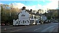
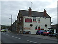
8
Wharncliffe Arms (#365 Burncross Road)
There is an OS benchmark Image on the front of the pub, about 2 feet from the near corner
Image: © Roger Templeman
Taken: 21 Jun 2013
0.20 miles
9
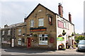
The Wharncliffe Arms, Burncross
On Burncross Road (B6546).
The number of this road is incorrectly shown as the B113 on some maps see https://www.sabre-roads.org.uk/wiki/index.php?title=B113_(Chapeltown)
Image: © JThomas
Taken: 27 Sep 2014
0.20 miles