IMAGES TAKEN NEAR TO
Burncross Road, SHEFFIELD, S35 1SL
Introduction
This page details the photographs taken nearby to Burncross Road, S35 1SL by members of the Geograph project.
The Geograph project started in 2005 with the aim of publishing, organising and preserving representative images for every square kilometre of Great Britain, Ireland and the Isle of Man.

There are currently over 7.5m images from over14,400 individuals and you can help contribute to the project by visiting https://www.geograph.org.uk
Image Map
Images are licensed for reuse under creativecommons.org/licenses/by-sa/2.0
Notes
- Clicking on the map will re-center to the selected point.
- The higher the marker number, the further away the image location is from the centre of the postcode.
Image Listing (26 Images Found)
Images are licensed for reuse under creativecommons.org/licenses/by-sa/2.0
Image
Details
Distance
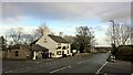
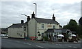
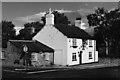
4
The Crown & Cushion, Chapeltown (1985)
The pub has been greatly extended since it was my local in 1985.
Image: © Graham Hogg
Taken: Unknown
0.13 miles
6
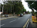
Burncross Road (B6546)
Heading east.
The number of this road is incorrectly shown as the B113 on some maps see https://www.sabre-roads.org.uk/wiki/index.php?title=B113_(Chapeltown)
Image: © JThomas
Taken: 27 Sep 2014
0.13 miles
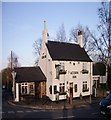
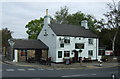
7
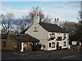
The Acorn Inn
Public house on Burncross Road
Image: © Graham Hogg
Taken: 23 Nov 2020
0.14 miles
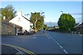
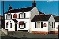
10
The Acorn Inn, Burncross
On Burncross Road.
Image: © JThomas
Taken: 27 Sep 2014
0.15 miles