IMAGES TAKEN NEAR TO
Hawksley Rise, SHEFFIELD, S35 0JB
Introduction
This page details the photographs taken nearby to Hawksley Rise, S35 0JB by members of the Geograph project.
The Geograph project started in 2005 with the aim of publishing, organising and preserving representative images for every square kilometre of Great Britain, Ireland and the Isle of Man.

There are currently over 7.5m images from over14,400 individuals and you can help contribute to the project by visiting https://www.geograph.org.uk
Image Map
Images are licensed for reuse under creativecommons.org/licenses/by-sa/2.0
Notes
- Clicking on the map will re-center to the selected point.
- The higher the marker number, the further away the image location is from the centre of the postcode.
Image Listing (162 Images Found)
Images are licensed for reuse under creativecommons.org/licenses/by-sa/2.0
Image
Details
Distance
1
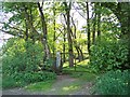
Entrance to Birks Wood, Oughtibridge, from Skelton Rise
Image: © Terry Robinson
Taken: 8 May 2008
0.08 miles
2
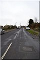
Tour de France 2014 Route - Haggstones Road and Church Street Corner, Oughtibridge - 1
After leaving Worrall Village, the riders will approach Oughtibridge, down Haggstones Road
and Church Street. This view is looking up Haggstones Road towards Birks Wood Drive.
As the riders will be approaching this spot at speed … let's hope the Horse Droppings are
swept up (and according to tradition put on somebody's Roses), and the Road Grid is repaired!
For more views in this area … see …
Image
Image
Image
Image
Image: © Terry Robinson
Taken: 8 Mar 2014
0.09 miles
3
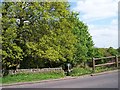
Footpath to Birks Wood, Hagg Stones Road, Oughtibridge
This path continues down from Worrall via Boggard Lane, through Hagg Stones Quarry and eventually reaches the River Don down in Oughtibridge valley.
Image: © Terry Robinson
Taken: 2 May 2009
0.10 miles
4
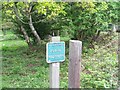
Footpath 49, Hagg Stones Road, Oughtibridge
This footpath runs from Hagg Stones Road down to Birks Wood in Oughtibridge ... be warned it is a bit boggy in places!
Image: © Terry Robinson
Taken: 2 May 2009
0.10 miles
5
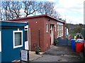
The 'Hengist' Building at Oughtibridge J & I School
Why 'Hengist' ... nobody seems to know! This 'extra' classroom was built in the early 1960's when the main school building was still situated off Church Street. My wife remembers it being 'her classroom' at that time but doesn't know anything else about it. Still in use in 2008 as part of the 'newer' school off Naylor Road.
Update in June 2020
Following some research it has now been established that this building was erected in the late 1950s - certainly appears on a OS map dated 1959. It was erected to give additional classroom space for the, then, existing Oughtibridge J & I School, which was struggling to cope with the growing population of Oughtibridge.
At this time there were already plans to replace the existing school with a new building on nearby land. The ‘Hengist’ building was therefore sited in the new location so that it would remain within the new school boundary.
It is named ‘Hengist’ as it was a more modern version of the HORSA Huts which were introduced as a ‘stop gap’ solution to accommodate the ‘extra’ pupils created by ROSLA in 1947, when the school leaving age was raised to 15 years.
HORSA meaning Hutting Operation for the Raising of the School leaving Age.
Why Hengist? Well, Hengist and Horsa are legendary brothers who led the Angles, Saxons and Jutes in their invasion of Britain in the 5th Century.
Many things have been named after the brothers ... probably the most famous being WW2 Gliders. Horsa Gliders were notably used in the Battle for the Pegasus Bridge in Normandy.
Stena named two ferries after the brothers.
Image: © Terry Robinson
Taken: 30 Mar 2008
0.10 miles
6
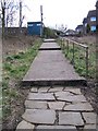
Old and New Paths meet in Oughtibridge!
This path leads from Church Street to Naylor Road, via 'The Ginnel', to Oughtibridge J & I School. I think I prefer the old style!
Image: © Terry Robinson
Taken: 30 Mar 2008
0.11 miles
7

Footgate Close Footpath with Boy, Oughtibridge, Sheffield
This young boy appeared just as I pressed the shutter ... he very politely apologised for spoiling the shot when he passed me - good for him, there is hope!
For a view without the boy ... see ...
Image
Image: © Terry Robinson
Taken: 16 Feb 2013
0.12 miles
8

Footpath from Footgate Close, Oughtibridge, Sheffield
For a view from the other direction ... see ...
Image
This path leads through to a path next to the School and the Steps leading down to Alford Avenue and thence to Oughtibridge Village.
See ...
Image
Image
Image: © Terry Robinson
Taken: 16 Feb 2013
0.12 miles
9

Footgate Close Footpath without Boy, Oughtibridge, Sheffield
The steps leading up from Alford Avenue emerge just by the gate at the end of the path ... see ...
Image
Oughtibridge School is behind the Green Railings and Gate.
For a view of the footpath, complete with boy ... see ...
Image
Image: © Terry Robinson
Taken: 16 Feb 2013
0.12 miles
10
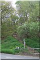
Hagg Stones Footpath, Haggstones Road, Oughtibridge
This footpath leads up through (the former) Hagg Stones Quarry
to Boggard Lane ... and onwards to Worrall.
Used by the 'fitter' pupils from Bradfield School as a shortcut to and
from Oughtibridge. The ' non-fit' pupils use the School Bus!
Image: © Terry Robinson
Taken: 2 May 2009
0.12 miles