IMAGES TAKEN NEAR TO
Old Lane, SHEFFIELD, S35 0HH
Introduction
This page details the photographs taken nearby to Old Lane, S35 0HH by members of the Geograph project.
The Geograph project started in 2005 with the aim of publishing, organising and preserving representative images for every square kilometre of Great Britain, Ireland and the Isle of Man.

There are currently over 7.5m images from over14,400 individuals and you can help contribute to the project by visiting https://www.geograph.org.uk
Image Map
Images are licensed for reuse under creativecommons.org/licenses/by-sa/2.0
Notes
- Clicking on the map will re-center to the selected point.
- The higher the marker number, the further away the image location is from the centre of the postcode.
Image Listing (9 Images Found)
Images are licensed for reuse under creativecommons.org/licenses/by-sa/2.0
Image
Details
Distance
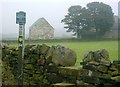
1
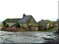
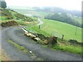
Abandoned farm buildings at Coomes Vale
Image: © Graham Hogg
Taken: 26 Jan 2012
0.20 miles
4
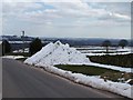
Snow Pile on Burnt Hill Lane, Oughtibridge - 2
See also ...
Image
Image: © Terry Robinson
Taken: 31 Mar 2013
0.21 miles
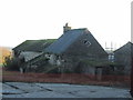
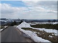
5
Coumes Farm
View of Coumes Farm, near Oughtibridge from Burnt Hill Lane.
Image: © Brian Ward
Taken: 10 Oct 2006
0.21 miles
6
Snow Pile on Burnt Hill Lane, Oughtibridge - 1
See also ...
Image
Image: © Terry Robinson
Taken: 31 Mar 2013
0.21 miles
7
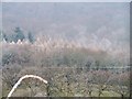
Hoar Frost on the tops of the trees, near Oughtibridge
Image: © Terry Robinson
Taken: 20 Feb 2008
0.22 miles
8
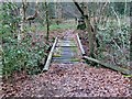
Footbridge over Coumes Brook
On a little used footpath through woodland to the west of Oughtibridge.
Image: © Graham Hogg
Taken: 26 Jan 2012
0.22 miles
9
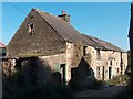
Burnt Hill Farm
View of Burnt Hill Farm near Worrall from Burnt Hill Lane.
Image: © Brian Ward
Taken: 10 Oct 2006
0.23 miles