IMAGES TAKEN NEAR TO
Foldrings, SHEFFIELD, S35 0GE
Introduction
This page details the photographs taken nearby to Foldrings, S35 0GE by members of the Geograph project.
The Geograph project started in 2005 with the aim of publishing, organising and preserving representative images for every square kilometre of Great Britain, Ireland and the Isle of Man.

There are currently over 7.5m images from over14,400 individuals and you can help contribute to the project by visiting https://www.geograph.org.uk
Image Map
Images are licensed for reuse under creativecommons.org/licenses/by-sa/2.0
Notes
- Clicking on the map will re-center to the selected point.
- The higher the marker number, the further away the image location is from the centre of the postcode.
Image Listing (7 Images Found)
Images are licensed for reuse under creativecommons.org/licenses/by-sa/2.0
Image
Details
Distance
1
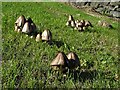
Clumps of mushrooms growing by Bents Hill Lane
Near the start of the track to Benteholme Farm.
Image: © Neil Theasby
Taken: 25 Sep 2018
0.01 miles
5
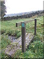
Footbridge near Glen Howe
A small footbridge near Glen Howe Park, Wharncliffe Side. The plaque says, 'this bridge was funded by the Peak and Northern Footpaths Society for the benefit of all who pass this way. Happy walking!'
Image: © Dave Pickersgill
Taken: 25 Oct 2012
0.19 miles
6
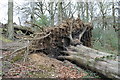
Glen Howe Park, Wharncliffe Side
Fallen tree in Glen Howe Park, Wharncliffe Side
Image: © Dave Pickersgill
Taken: 3 May 2013
0.20 miles
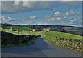
7
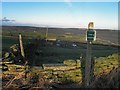
Footpath to Hill House from Lumb Lane
Image: © Steve Fareham
Taken: 23 Dec 2012
0.24 miles