IMAGES TAKEN NEAR TO
Crag View Close, SHEFFIELD, S35 0GA
Introduction
This page details the photographs taken nearby to Crag View Close, S35 0GA by members of the Geograph project.
The Geograph project started in 2005 with the aim of publishing, organising and preserving representative images for every square kilometre of Great Britain, Ireland and the Isle of Man.

There are currently over 7.5m images from over14,400 individuals and you can help contribute to the project by visiting https://www.geograph.org.uk
Image Map
Images are licensed for reuse under creativecommons.org/licenses/by-sa/2.0
Notes
- Clicking on the map will re-center to the selected point.
- The higher the marker number, the further away the image location is from the centre of the postcode.
Image Listing (199 Images Found)
Images are licensed for reuse under creativecommons.org/licenses/by-sa/2.0
Image
Details
Distance
1
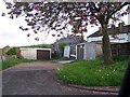
Lock-up Garages on Crag View, Oughtibridge
These garages, available to rent, were originally provided for the fortunate few residents of the Crag View Estate who owned cars ... now used for anything but!
Image: © Terry Robinson
Taken: 15 May 2008
0.03 miles
2
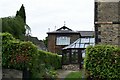
Stable Block for Broomfield House, Oughtibridge
Attached to Broomfield House is an original stable block, now converted into additional accommodation. Image
Image: © Terry Robinson
Taken: 19 May 2008
0.04 miles
3
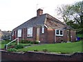
'Old Style' Bungalow, Crag View Crescent - formerly The Planting, Oughtibridge
Six of these Semi-Detached Bungalows were built in the
1940's and they are still offering good accommodation.
When they were built they were in a small cul-de-sac
with the address being The Planting.
Eventually the nearby Crag View Crescent was developed from another
cul-de-sac and extended to join up with The Planting.
This formed a full Crescent and these Bungalows were re-numbered.
As part of this development a further five, more modern Semi-Detached Bungalows
were built next to the original development … see ...
Image
Image: © Terry Robinson
Taken: 15 May 2008
0.04 miles
4
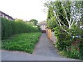
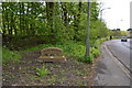
Path from Bedford Road to Crag View Close, Oughtibridge
Short cut to Crag View Close and Crescent ... used by people coming home on the 'Bus.
Image: © Terry Robinson
Taken: 15 May 2008
0.04 miles
5
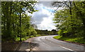
Langsett Road North, Oughtibridge, Sheffield
See also ...
Image
One of the newly placed Oughtibridge Village Signs is visible on the left verge ... see ...
Image
Image
Image: © Terry Robinson
Taken: 16 May 2013
0.04 miles
6
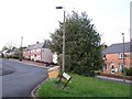
Oughtibridge Sign, Langsett Road North, Oughtibridge, Sheffield - 1
Vehicles travelling from Stocksbridge, pass the newly placed Village Sign, as they head for Hillsborough and Sheffield
For a closer view of the sign ... see ...
Image
A similar sign was placed at the southern end of the village ... see ...
Image
Image
Image: © Terry Robinson
Taken: 16 May 2013
0.04 miles
7
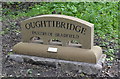
Oughtibridge Sign, Langsett Road North, Oughtibridge, Sheffield - 2
The plate attached to the sign reads ...
Provided in April 2013 by the
Oughtibridge Village Community Association
part-funded by the
Northern Community Assembly
For more information ... see ...
Image
Image: © Terry Robinson
Taken: 16 May 2013
0.05 miles
8
One side of Crag View Crescent, Oughtibridge
Image: © Terry Robinson
Taken: 15 May 2008
0.05 miles
9
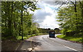
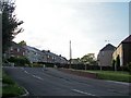
Langsett Road North with Bus, Oughtibridge, Sheffield
The bus is one of fleet of Supertram Link buses which run every ten minutes or so, between Stocksbridge and the Supertram terminus at Middlewood ... see also ...
Image
To see the same view, without the bus ... see ...
Image
One of the newly placed Oughtibridge Village signs is visible on the left hand verge ... see ...
Image
Image
Image: © Terry Robinson
Taken: 16 May 2013
0.06 miles
10
... and the other side of Crag View Crescent, Oughtibridge
Image: © Terry Robinson
Taken: 15 May 2008
0.06 miles