IMAGES TAKEN NEAR TO
Yews Close, SHEFFIELD, S35 0BB
Introduction
This page details the photographs taken nearby to Yews Close, S35 0BB by members of the Geograph project.
The Geograph project started in 2005 with the aim of publishing, organising and preserving representative images for every square kilometre of Great Britain, Ireland and the Isle of Man.

There are currently over 7.5m images from over14,400 individuals and you can help contribute to the project by visiting https://www.geograph.org.uk
Image Map
Images are licensed for reuse under creativecommons.org/licenses/by-sa/2.0
Notes
- Clicking on the map will re-center to the selected point.
- The higher the marker number, the further away the image location is from the centre of the postcode.
Image Listing (69 Images Found)
Images are licensed for reuse under creativecommons.org/licenses/by-sa/2.0
Image
Details
Distance
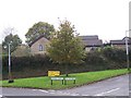
1
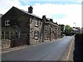
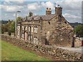
Shoulder of Mutton Pub at Worrall
Situated on Top Road, the "Shoulder" is one of two pubs in the village of Worrall, it is thought that parts of the structure were originally farm buildings before becoming licensed premises in the 1800s.
Image: © Michael Knapton
Taken: 29 May 2005
0.05 miles
2
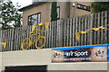
Yellow bikes promoting 'Le Grand D?part': The Blue Ball
The 2014 Tour de France is starting in Yorkshire and on day 2 will end in Sheffield. To promote the event 40 reclaimed bikes have been painted yellow and placed at various locations on the route and around the city. This one is in the car park of the Blue Ball pub, which has been given a fresh coat of yellow paint for the occasion. Image
Image: © Graham Hogg
Taken: 11 Jun 2014
0.05 miles
3
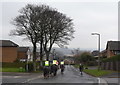
Cyclist and Riders on Kirk Edge Road, Worrall, near Oughtibridge
As requested … the cyclist, enjoying himself on this part of the
forthcoming Tour de France route, passed (very) wide and (very) slow
For more information … see …
Image
For more views … see …
Image
Image
Image
… and …
Image
Image: © Terry Robinson
Taken: 8 Mar 2014
0.06 miles
4
Tour de France 2014 Route - Worrall, near Oughtibridge - 4
This is the opposite view of Picture 3 … the riders will approach from the
top and pass the viewpoint - downhill and quickly I would imagine!
Long Lane is on the left, Top Road on the right.
That seat is still available … and looking good !!
For more Tour de France Route views in the Worrall area … see …
Image
Image
Image
Image
Image
Image
Image: © Terry Robinson
Taken: 8 Mar 2014
0.06 miles
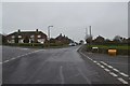
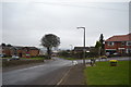
5
Road Junction at Worrall
Let's hope the tree survives the bonfire!
Image: © Terry Robinson
Taken: 3 Nov 2008
0.06 miles
6
Spring colour by the water trough
In the village centre
Image: © Graham Hogg
Taken: 30 Mar 2019
0.06 miles
7
Tour de France 2014 Route - Worrall, near Oughtibridge - 3
Continuing on from Picture 2 … This is the junction of Kirk Edge Road with
Long Lane on the right and Top Road on the left. Still down hill at this point.
That seat looks like a handy viewing point !!
For more Tour de France Route views in the Worrall area … see …
Image
Image
Image
Image
Image
Image
Image: © Terry Robinson
Taken: 8 Mar 2014
0.06 miles
8
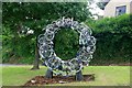
Up-Cycle sculpture
Constructed from old cycle wheels, frames and handlebars to celebrate the 2014 Tour de France which passed through the village in July.
Image: © Graham Hogg
Taken: 3 Jul 2014
0.06 miles
9
Public House in Worrall
The Shoulder of Mutton on Top Road in Worrall. I've included this http://www.shoulderofmuttoninn.co.uk/ to a concise potted history of the pub provided by Doug Sanderson and Malcolm Nunn.
Image: © Jonathan Clitheroe
Taken: 5 Aug 2011
0.07 miles
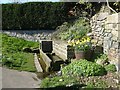
10
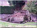
Lingard Well at Worrall
The clearance of some trees and overgrowth has made the ancient well and water trough much more visible.
Image: © Terry Robinson
Taken: 3 Nov 2008
0.07 miles