IMAGES TAKEN NEAR TO
Church Street, SHEFFIELD, S35 0AB
Introduction
This page details the photographs taken nearby to Church Street, S35 0AB by members of the Geograph project.
The Geograph project started in 2005 with the aim of publishing, organising and preserving representative images for every square kilometre of Great Britain, Ireland and the Isle of Man.

There are currently over 7.5m images from over14,400 individuals and you can help contribute to the project by visiting https://www.geograph.org.uk
Image Map
Images are licensed for reuse under creativecommons.org/licenses/by-sa/2.0
Notes
- Clicking on the map will re-center to the selected point.
- The higher the marker number, the further away the image location is from the centre of the postcode.
Image Listing (202 Images Found)
Images are licensed for reuse under creativecommons.org/licenses/by-sa/2.0
Image
Details
Distance
1
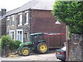
My Other Car Is A John Deere Tractor, Church Street, Oughtibridge
Image: © Terry Robinson
Taken: 7 Jul 2008
0.02 miles
2
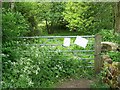
Gate to Kaye Meadows, Oughtibridge
The two notices, attached to the gate, give details of work to be carried out to the footpaths, in the nearby, Sensicall Park. Image
Image: © Terry Robinson
Taken: 26 May 2008
0.03 miles
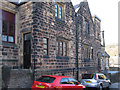
3
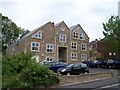
Apartment Block, Church Street, Oughtibridge
This impressive apartment block is built on land formerly occupied by the Parish Hall ... the Parish Hall was very dilapidated but must have held many memories for the old 'Oughtibridgers' and it's a shame it couldn't have been saved. Image
Image: © Terry Robinson
Taken: 26 May 2008
0.03 miles
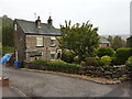
5
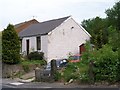
Cottage and Gate Posts, Church Street, Oughtibridge
Next door to the 'new' Apartments Block is this Cottage ... and a set of Gate Posts leading to - nowadays - nowhere. More history in these buildings than the new building! Image
Image: © Terry Robinson
Taken: 26 May 2008
0.04 miles
6
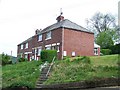
High Houses, Poplar Road, Oughtibridge
Image: © Terry Robinson
Taken: 26 May 2008
0.04 miles
7
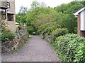
Path to Kaye Meadows, off Church Street, Oughtibridge
Kaye Meadows is a field which was donated to Bradfield Parish many years ago ... currently, controversially, being developed into Allotments. At the end of the path is a gate into the Meadow and access to Sensicall Park. Image
Image: © Terry Robinson
Taken: 26 May 2008
0.04 miles
8
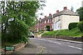
Poplar Place To Live, Oughtibridge
Poplar Road leads to Poplar Close!
Image: © Terry Robinson
Taken: 26 May 2008
0.05 miles
9
Oughtibridge - old school off Church Street
For an alternative view, please see Image
Image: © Dave Bevis
Taken: 13 Mar 2012
0.06 miles
10
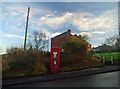
Coins not accepted here
Oughtibridge phone box.
Image: © Steve Fareham
Taken: 29 Nov 2008
0.07 miles