IMAGES TAKEN NEAR TO
Elliott Avenue, HOPE VALLEY, S33 9HQ
Introduction
This page details the photographs taken nearby to Elliott Avenue, S33 9HQ by members of the Geograph project.
The Geograph project started in 2005 with the aim of publishing, organising and preserving representative images for every square kilometre of Great Britain, Ireland and the Isle of Man.

There are currently over 7.5m images from over14,400 individuals and you can help contribute to the project by visiting https://www.geograph.org.uk
Image Map
Images are licensed for reuse under creativecommons.org/licenses/by-sa/2.0
Notes
- Clicking on the map will re-center to the selected point.
- The higher the marker number, the further away the image location is from the centre of the postcode.
Image Listing (15 Images Found)
Images are licensed for reuse under creativecommons.org/licenses/by-sa/2.0
Image
Details
Distance
1
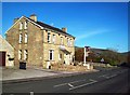
The Samuel Fox Inn, Bradwell
This inn is situated at the northern end of the village close to Bradwell Brook. This fairly new addition to the High Peak pub portfolio is named after one of Bradwell's most famous sons who, one morning in 1842 set out from the village on foot in order to establish a wire drawing business in Stocksbridge. There he developed the 'paragon' umbrella frame and the site of his successful business later evolved into the Stocksbridge Steel Works.
Image: © Jonathan Clitheroe
Taken: 17 Nov 2011
0.05 miles
2
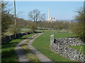
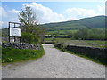
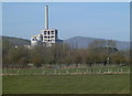
Farm track near Bradwell
A farm track off the B6049 near the edge of the village. The cement works loom large in many views in and around the Hope valley.
Image: © Andrew Hill
Taken: 29 Mar 2012
0.06 miles
3
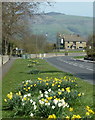
Main Road, Bradwell
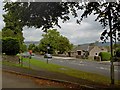
North of the village centre, with daffodils in the wide verge and a view of Win Hill.
Image: © Andrew Hill
Taken: 29 Mar 2012
0.07 miles
4
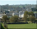
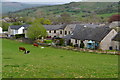
A Bradwell view
View of part of the north side of the village and the houses up to the Smalldale area upper right. Seen from the main road.
Image: © Andrew Hill
Taken: 29 Mar 2012
0.10 miles
7
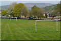
Triangular recreation ground, Bradwell
Image: © David Martin
Taken: 23 Apr 2019
0.18 miles
8
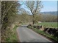
Lane towards Hope from Bradwell
The lane passes through a quarrying area beyond the trees in the middle distance.
Image: © Andrew Hill
Taken: 29 Mar 2012
0.20 miles
9
Bradwell fire station
From Town Lane.
Image: © Steve Fareham
Taken: 18 Aug 2009
0.21 miles
10
Fields between Bradwell and Hope
View from the lane with the cement works in the next square looming large. Mam Tor in the distance.
Image: © Andrew Hill
Taken: 29 Mar 2012
0.22 miles