IMAGES TAKEN NEAR TO
Granby Road, HOPE VALLEY, S33 9GU
Introduction
This page details the photographs taken nearby to Granby Road, S33 9GU by members of the Geograph project.
The Geograph project started in 2005 with the aim of publishing, organising and preserving representative images for every square kilometre of Great Britain, Ireland and the Isle of Man.

There are currently over 7.5m images from over14,400 individuals and you can help contribute to the project by visiting https://www.geograph.org.uk
Image Map (Loading...)


Getting Data...Please wait
Leaflet Map data © OpenStreetMap
Images are licensed for reuse under creativecommons.org/licenses/by-sa/2.0
Notes
- Clicking on the map will re-center to the selected point.
- The higher the marker number, the further away the image location is from the centre of the postcode.
Image Listing (46 Images Found)
Images are licensed for reuse under creativecommons.org/licenses/by-sa/2.0
Image
Details
Distance
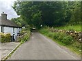
3
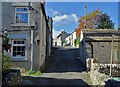
Bradwell, Charlotte Lane
Narrow lane on the outskirts of the village of Bradwell
Image: © David Dixon
Taken: 30 Jun 2023
0.04 miles
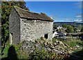
5
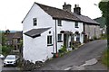
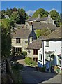
Cottages on Charlotte Lane
Above the village of Bradwell in the Hope Valley.
Image: © David Dixon
Taken: 30 Jun 2023
0.05 miles
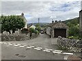
6
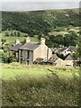
On Far Hill looking to Hill Head, Bradwell
Image: © Neil Theasby
Taken: 27 Sep 2018
0.06 miles
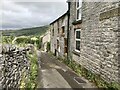
7
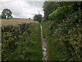
Moorbrook Lane (path)
A narrow path leading westwards from Granby Road.
Image: © David Dixon
Taken: 1 Jul 2023
0.07 miles
9
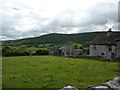
Back of Hill Head
Field behind Hill Head, a road running downhill to the centre of Bradwell.
Image: © Peter Barr
Taken: 15 Jul 2010
0.09 miles