IMAGES TAKEN NEAR TO
Mill Bridge, HOPE VALLEY, S33 8WR
Introduction
This page details the photographs taken nearby to Mill Bridge, S33 8WR by members of the Geograph project.
The Geograph project started in 2005 with the aim of publishing, organising and preserving representative images for every square kilometre of Great Britain, Ireland and the Isle of Man.

There are currently over 7.5m images from over14,400 individuals and you can help contribute to the project by visiting https://www.geograph.org.uk
Image Map
Images are licensed for reuse under creativecommons.org/licenses/by-sa/2.0
Notes
- Clicking on the map will re-center to the selected point.
- The higher the marker number, the further away the image location is from the centre of the postcode.
Image Listing (311 Images Found)
Images are licensed for reuse under creativecommons.org/licenses/by-sa/2.0
Image
Details
Distance
1
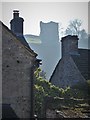
Peveril Castle seen over Castleton rooftops
Peveril Castle is an ancient strategic structure that looks over Castleton and The Hope Valley.
Image: © Neil Theasby
Taken: 26 Feb 2019
0.00 miles
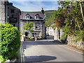
2
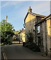
Millbridge, Castleton
The street climbs from Trickett Bridge towards the centre of the village. Peveril Castle can be seen up the hillside.
Image: © Derek Harper
Taken: 8 Jul 2014
0.01 miles
4
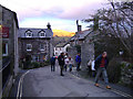
Castleton street
Derbyshire
With Mam Tor in evening sunlight in the distance
Image: © Bob Abell
Taken: 1 Jan 2006
0.02 miles
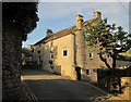
6
Millbridge, Castleton
The Millbridge and Mill Lane area of Castleton is characterised by former agricultural buildings and small industrial complexes, including a former cotton mill, corn mill and saw mill which have now been converted to residential use. Buildings are typically oriented with their gable ends onto the lane.
Image: © David Dixon
Taken: 17 May 2014
0.03 miles
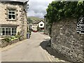
7
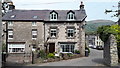
House on Back Street, Castleton
Back Street is a continuation of Millbridge, rising to the centre of the village. This is the Ramblers Rest, a guest house and cafe.
Image: © Derek Harper
Taken: 8 Jul 2014
0.03 miles
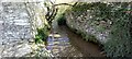
10
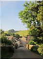
Trickett Bridge, Castleton
A similar view to Image, with Hollowford Road entering the village. The bridge is across Peakshole Water. Behind rises Michill Bank.
Image: © Derek Harper
Taken: 8 Jul 2014
0.03 miles