IMAGES TAKEN NEAR TO
How Lane, HOPE VALLEY, S33 8WJ
Introduction
This page details the photographs taken nearby to How Lane, S33 8WJ by members of the Geograph project.
The Geograph project started in 2005 with the aim of publishing, organising and preserving representative images for every square kilometre of Great Britain, Ireland and the Isle of Man.

There are currently over 7.5m images from over14,400 individuals and you can help contribute to the project by visiting https://www.geograph.org.uk
Image Map
Images are licensed for reuse under creativecommons.org/licenses/by-sa/2.0
Notes
- Clicking on the map will re-center to the selected point.
- The higher the marker number, the further away the image location is from the centre of the postcode.
Image Listing (253 Images Found)
Images are licensed for reuse under creativecommons.org/licenses/by-sa/2.0
Image
Details
Distance
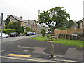
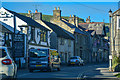
4
How Lane, Castleton
Looking towards the centre of the village along the main road (the A6187) from Hope.
Image: © Andrew Hill
Taken: 28 Sep 2012
0.04 miles
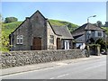
6
Castleton : How Lane A6187
A road heading through Castleton.
Image: © Lewis Clarke
Taken: 1 Oct 2018
0.05 miles
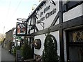
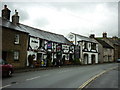
7
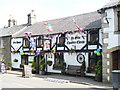
Ye Olde Cheshire Cheese
Attractive half-timbered pub dressed up for Garland Day in Castleton.
Image: © Colin Smith
Taken: 29 May 2009
0.05 miles
8
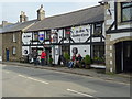
Ye Olde Cheshire Cheese
Warm enough to sit out in early April.
Image: © John M
Taken: 6 Apr 2018
0.06 miles
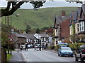
10
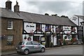
"Ye Olde Cheshire Cheese", Castleton
You can just see Peveril Castle peeping above the pub's roof.
Image: © Neil Theasby
Taken: 23 Aug 2012
0.06 miles