IMAGES TAKEN NEAR TO
Edale, HOPE VALLEY, S33 7ZA
Introduction
This page details the photographs taken nearby to S33 7ZA by members of the Geograph project.
The Geograph project started in 2005 with the aim of publishing, organising and preserving representative images for every square kilometre of Great Britain, Ireland and the Isle of Man.

There are currently over 7.5m images from over14,400 individuals and you can help contribute to the project by visiting https://www.geograph.org.uk
Image Map
Images are licensed for reuse under creativecommons.org/licenses/by-sa/2.0
Notes
- Clicking on the map will re-center to the selected point.
- The higher the marker number, the further away the image location is from the centre of the postcode.
Image Listing (132 Images Found)
Images are licensed for reuse under creativecommons.org/licenses/by-sa/2.0
Image
Details
Distance
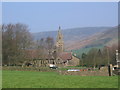
1
Edale on a wet day
The line of Kinder behind dominates the village.
Image: © Bill Boaden
Taken: 29 Mar 2008
0.03 miles
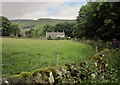
2
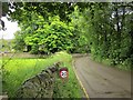
Marys Lane, Edale
Houses, largely hidden by greenery at this time of the year, are strung out along the lane south of the village centre.
Image: © Derek Harper
Taken: 8 Jul 2014
0.04 miles
3
Peak & Northern Footpaths Society sign no. 112
The history of this sign can be seen here Image
Image: © Graham Hogg
Taken: 30 Jun 2014
0.05 miles
4
Peak & Northern Footpaths Society signpost 112
The plate tells the history of this sign. See Image
Image: © Graham Hogg
Taken: 30 Jun 2014
0.05 miles
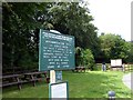
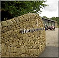
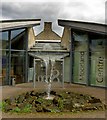
5
The entrance to the Visitor Centre
A chance to show off dry stone walling skills.
Image: © Bill Boaden
Taken: 29 Mar 2008
0.05 miles
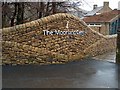
6
Entrance to The Moorland Centre Edale
A fine example of dry stone walling.
Image: © Steve Fareham
Taken: 29 Aug 2008
0.05 miles
7
Moorland Centre, Edale
The centre, opened in 2006, is also shown in http://www.geograph.org.uk/search.php?i=54926368 . This is the entrance off Marys Lane. I think it's almost stopped raining.
Image: © Derek Harper
Taken: 8 Jul 2014
0.05 miles
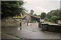
8
The Moorland Centre Edale
Complete with waterfall from its roof.
Image: © Steve Fareham
Taken: 29 Aug 2008
0.06 miles
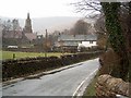
9
Another wet day in Edale
Compare with Image, also showing the church and the cottages http://list.historicengland.org.uk/resultsingle.aspx?uid=1338205&searchtype=mapsearch .
Image: © Derek Harper
Taken: 8 Jul 2014
0.06 miles