IMAGES TAKEN NEAR TO
Edale Road, HOPE VALLEY, S33 6SF
Introduction
This page details the photographs taken nearby to Edale Road, S33 6SF by members of the Geograph project.
The Geograph project started in 2005 with the aim of publishing, organising and preserving representative images for every square kilometre of Great Britain, Ireland and the Isle of Man.

There are currently over 7.5m images from over14,400 individuals and you can help contribute to the project by visiting https://www.geograph.org.uk
Image Map
Images are licensed for reuse under creativecommons.org/licenses/by-sa/2.0
Notes
- Clicking on the map will re-center to the selected point.
- The higher the marker number, the further away the image location is from the centre of the postcode.
Image Listing (63 Images Found)
Images are licensed for reuse under creativecommons.org/licenses/by-sa/2.0
Image
Details
Distance
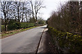
1
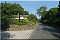
Along Edale Road
Looking along Edale Road on the north side of Hope.
Image: © DS Pugh
Taken: 28 Aug 2022
0.00 miles

3
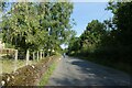
Edale Road north of the railway
Looking along Edale Road in Hope.
Image: © DS Pugh
Taken: 28 Aug 2022
0.02 miles
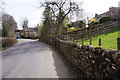
4
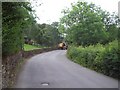
Tractor on Edale Road
A tractor rumbles along this narrow lane which follows the course of the River Noe.
Image: © Jonathan Clitheroe
Taken: 7 Jul 2011
0.03 miles
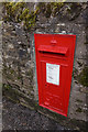
5
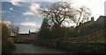
The first postbox in Hope
The rail link bridge from Hope Cement works is just visible in the background.
Image: © Steve Fareham
Taken: 29 Nov 2008
0.03 miles
9
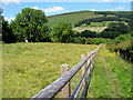
Footpath
Footpath leading to Edale Road about 100 yards away.
Image: © Stephen Burton
Taken: 24 Jun 2009
0.07 miles