IMAGES TAKEN NEAR TO
Castleton Road, HOPE VALLEY, S33 6SB
Introduction
This page details the photographs taken nearby to Castleton Road, S33 6SB by members of the Geograph project.
The Geograph project started in 2005 with the aim of publishing, organising and preserving representative images for every square kilometre of Great Britain, Ireland and the Isle of Man.

There are currently over 7.5m images from over14,400 individuals and you can help contribute to the project by visiting https://www.geograph.org.uk
Image Map
Images are licensed for reuse under creativecommons.org/licenses/by-sa/2.0
Notes
- Clicking on the map will re-center to the selected point.
- The higher the marker number, the further away the image location is from the centre of the postcode.
Image Listing (99 Images Found)
Images are licensed for reuse under creativecommons.org/licenses/by-sa/2.0
Image
Details
Distance
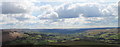
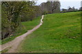
2
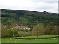
Overlooking Hope
And beyond to Hope Bank and the distinctive Win Hill.
Image: © Graham Hogg
Taken: 11 May 2012
0.04 miles
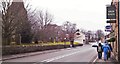
3
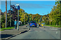
Hope : Castleton Road A6187
Crossing over a roundabout in Hope.
Image: © Lewis Clarke
Taken: 1 Oct 2018
0.05 miles
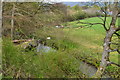
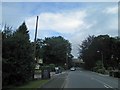
7
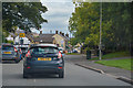
Hope : Castleton Road A6187
Looking along Castleton Road in Hope.
Image: © Lewis Clarke
Taken: 1 Oct 2018
0.12 miles