IMAGES TAKEN NEAR TO
Parsons Lane, HOPE VALLEY, S33 6RB
Introduction
This page details the photographs taken nearby to Parsons Lane, S33 6RB by members of the Geograph project.
The Geograph project started in 2005 with the aim of publishing, organising and preserving representative images for every square kilometre of Great Britain, Ireland and the Isle of Man.

There are currently over 7.5m images from over14,400 individuals and you can help contribute to the project by visiting https://www.geograph.org.uk
Image Map
Images are licensed for reuse under creativecommons.org/licenses/by-sa/2.0
Notes
- Clicking on the map will re-center to the selected point.
- The higher the marker number, the further away the image location is from the centre of the postcode.
Image Listing (22 Images Found)
Images are licensed for reuse under creativecommons.org/licenses/by-sa/2.0
Image
Details
Distance
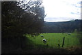
1
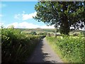
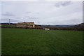
Parsons Lane
Heading north towards Aston with Win Hill (SK1885) on the horizon.
Image: © Jonathan Clitheroe
Taken: 7 Jul 2011
0.12 miles
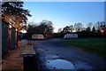
4
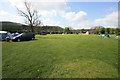
Hardhurst Farm Campsite
There is also a caravan field adjacent.
Image: © Bob Jenkins
Taken: 2 May 2009
0.15 miles
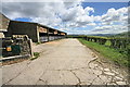
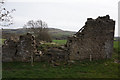
7
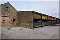
Ryecroft on Parsons Lane
Hallum Barn on OS maps.
Image: © Ian S
Taken: 23 Mar 2019
0.20 miles
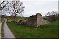
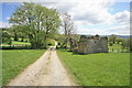
8
Ryecroft on Parsons Lane
Hallum Barn on OS maps.
Image: © Ian S
Taken: 23 Mar 2019
0.20 miles