IMAGES TAKEN NEAR TO
Ashopton Road, HOPE VALLEY, S33 0DB
Introduction
This page details the photographs taken nearby to Ashopton Road, S33 0DB by members of the Geograph project.
The Geograph project started in 2005 with the aim of publishing, organising and preserving representative images for every square kilometre of Great Britain, Ireland and the Isle of Man.

There are currently over 7.5m images from over14,400 individuals and you can help contribute to the project by visiting https://www.geograph.org.uk
Image Map
Images are licensed for reuse under creativecommons.org/licenses/by-sa/2.0
Notes
- Clicking on the map will re-center to the selected point.
- The higher the marker number, the further away the image location is from the centre of the postcode.
Image Listing (60 Images Found)
Images are licensed for reuse under creativecommons.org/licenses/by-sa/2.0
Image
Details
Distance
2
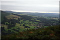
Bamford From Win Hill
From the east of the summit at the edge of the Win Hill Plantation.
Image: © David Lally
Taken: 25 Aug 2008
0.02 miles
3
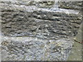
Cut Mark Bamford Roman Catholic Chapel
as above
Image: © Monica Stagg
Taken: 11 Mar 2015
0.03 miles
4
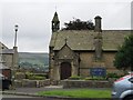
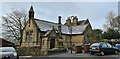
Our Lady of Sorrows Catholic Church Bamford
On Ashopton Road
Image: © Martin Dawes
Taken: 9 Sep 2015
0.03 miles
5
Catholic church of Our Lady of Sorrows, Bamford
Image: © Chris Morgan
Taken: 30 Dec 2020
0.03 miles


9

The Anglers, Bamford
Community pub, but currently shut due to Covid regulations.
Image: © Chris Morgan
Taken: 30 Dec 2020
0.07 miles