IMAGES TAKEN NEAR TO
Thornhill, HOPE VALLEY, S33 0BR
Introduction
This page details the photographs taken nearby to Thornhill, S33 0BR by members of the Geograph project.
The Geograph project started in 2005 with the aim of publishing, organising and preserving representative images for every square kilometre of Great Britain, Ireland and the Isle of Man.

There are currently over 7.5m images from over14,400 individuals and you can help contribute to the project by visiting https://www.geograph.org.uk
Image Map
Images are licensed for reuse under creativecommons.org/licenses/by-sa/2.0
Notes
- Clicking on the map will re-center to the selected point.
- The higher the marker number, the further away the image location is from the centre of the postcode.
Image Listing (48 Images Found)
Images are licensed for reuse under creativecommons.org/licenses/by-sa/2.0
Image
Details
Distance

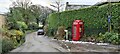
5
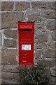
Victorian postbox on Thornhill Lane, Thornhill
Image: © Ian S
Taken: 23 Mar 2019
0.03 miles
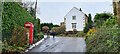
6
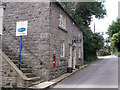
The Moot
The Building was previously used as a village meeting place including Sunday school for the children. It has now been converted into a cottage.
Image: © Stephen Burton
Taken: 5 Sep 2012
0.03 miles
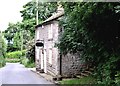
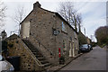
8

The junction of Carr Lane with Thornhill Lane
Image: © Ian S
Taken: 27 May 2011
0.03 miles
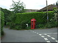
9
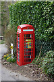
Former telephone kiosk, Thornhill
Now housing a defibrillator.
Image: © Ian S
Taken: 23 Mar 2019
0.03 miles
10
Thornhill Lane, Thornhill
Telephone box now housing a defibrillator
Image: © Chris Morgan
Taken: 30 Dec 2020
0.05 miles