IMAGES TAKEN NEAR TO
Pinfold Hill, HOPE VALLEY, S32 3YL
Introduction
This page details the photographs taken nearby to Pinfold Hill, S32 3YL by members of the Geograph project.
The Geograph project started in 2005 with the aim of publishing, organising and preserving representative images for every square kilometre of Great Britain, Ireland and the Isle of Man.

There are currently over 7.5m images from over14,400 individuals and you can help contribute to the project by visiting https://www.geograph.org.uk
Image Map
Images are licensed for reuse under creativecommons.org/licenses/by-sa/2.0
Notes
- Clicking on the map will re-center to the selected point.
- The higher the marker number, the further away the image location is from the centre of the postcode.
Image Listing (69 Images Found)
Images are licensed for reuse under creativecommons.org/licenses/by-sa/2.0
Image
Details
Distance
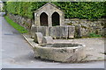
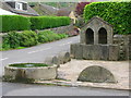
1
Curbar well and horse trough
In the centre of the small village of Curbar is a junction that has this old well and horse trough. Behind the village is one of the gritstone edges that characterises this area. When I was a child the water of that well seemed to taste so sweet!
Image: © Kathy E
Taken: 2 May 2004
0.04 miles
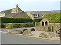
2
Horse trough and millstones
Most people here use a different sort of horse power these days.
Image: © Graham Hogg
Taken: 21 Jul 2010
0.05 miles
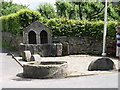
4
A use for redundant millstones
The spring and horse trough at Curbar are nicely protected by these millstones which no are longer required for their intended use.
Image: © John H Darch
Taken: 27 May 2006
0.06 miles
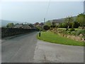
6
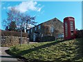
Cliff Lane road junction in Upper Curbar village
Image: © Neil Theasby
Taken: 5 Mar 2012
0.10 miles
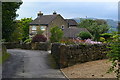
8
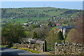
Curbar village
Just before the cross roads in the middle of Curbar village. In the distance is Froggatt Edge.
Image: © Kathy E
Taken: 2 May 2004
0.11 miles
9
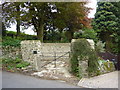
Curbar Pinfold, restored
A pinfold was an enclosure built in medieval villages for stray animals. The Pinder rounded up the cows and sheep, and the owners had to pay for their release.
This pinfold was restored by Curbar Parish Council and the Peak District National Park Authority in 2010.
Image: © Peter Barr
Taken: 15 May 2011
0.14 miles