IMAGES TAKEN NEAR TO
The Crofts, HOPE VALLEY, S32 1DG
Introduction
This page details the photographs taken nearby to The Crofts, S32 1DG by members of the Geograph project.
The Geograph project started in 2005 with the aim of publishing, organising and preserving representative images for every square kilometre of Great Britain, Ireland and the Isle of Man.

There are currently over 7.5m images from over14,400 individuals and you can help contribute to the project by visiting https://www.geograph.org.uk
Image Map
Images are licensed for reuse under creativecommons.org/licenses/by-sa/2.0
Notes
- Clicking on the map will re-center to the selected point.
- The higher the marker number, the further away the image location is from the centre of the postcode.
Image Listing (230 Images Found)
Images are licensed for reuse under creativecommons.org/licenses/by-sa/2.0
Image
Details
Distance
1
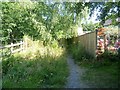
Approaching the cricket ground
The footpath approaches the cricket ground.
Image: © Michael Dibb
Taken: 29 Jun 2018
0.03 miles
2
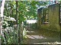
Behind the houses
After leaving Main Road (A6187), the footpath passes behind a terrace of houses.
Image: © Michael Dibb
Taken: 29 Jun 2018
0.04 miles
3
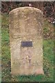
Old Milestone in The Crofts, by the A6187, Hathersage
Carved stone post near the A6187 (was A625), in parish of HATHERSAGE (DERBYSHIRE DALES District), in The Crofts, at junction with Main Road, opposite service station, to left of public toilets, on grass behind stone wall at junction, on East side of road, facing west. Hathersage stone, erected by the Sheffield & Chapel en le Frith turnpike trust in the 19th century.
Inscription reads:-
(Sheffie)ld
10
MILES
(modern plaque)
10 MILES
TO
SHEFFIELD
Milestone Society National ID: DE_SFCH10a.
Image: © J Higgins & C Minto
Taken: 1 Nov 2002
0.04 miles
4
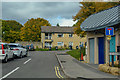
Hathersage : The Crofts
Off of Main Road.
Image: © Lewis Clarke
Taken: 1 Oct 2018
0.04 miles
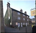
5
A retail oddity
A fish and chip shop closed at 5 in the evening. How odd.
Image: © Bob Harvey
Taken: 15 Feb 2023
0.04 miles
6
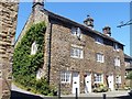
Bank Cottages
Formerly a workshop, now three cottages. Built in 1781, the cottages are listed, grade II, with details at: https://www.historicengland.org.uk/listing/the-list/list-entry/1158559
Image: © Michael Dibb
Taken: 29 Jun 2018
0.04 miles
7
The 1781 cottages, Besom Lane
Now known as Bank Cottages because a 19th century bank was built in front of them, these are listed by Historic England as "The 1781 cottages" (https://historicengland.org.uk/listing/the-list/list-entry/1158559?section=official-list-entry ). The listing says "Former workshop, now a row of cottages. Dated 1781". There is a little more detail in the Derbyshire Historic Environment Record (https://her.derbyshire.gov.uk/Monument/MDR6641 ), which says it was used as a button factory.
You will notice that windows have, at some time, been removed from the upper stories of number 1. There is a circular plaque, which superficially appears blank, but is the datestone referred to in the Derbyshire record. See Image
Image: © Bob Harvey
Taken: 15 Feb 2023
0.04 miles
8
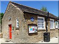
Information board at the vets
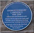
The building is occupied by the Hope Valley Veterinary Clinic. The blue plaque is to George Herbert Lawrence, philanthropist who funded many local buildings and other projects.
Image: © Michael Dibb
Taken: 29 Jun 2018
0.05 miles
9
Plaque in Hathersage
Plaque on the Village Rooms to a local philanthropist.
Image: © Bob Harvey
Taken: 15 Feb 2023
0.05 miles
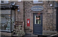
10
Wall posting box
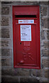
The posting box outside the Fish and Chip shop seen in Image The original post office was the other side of the main road, so why this is here is a bit of a puzzle.
It is (was?) one of the priority post boxes designated during the pandemic.
This box is numbered S32 556
Image: © Bob Harvey
Taken: 15 Feb 2023
0.05 miles