IMAGES TAKEN NEAR TO
Mayfield Terrace, HOPE VALLEY, S32 1BE
Introduction
This page details the photographs taken nearby to Mayfield Terrace, S32 1BE by members of the Geograph project.
The Geograph project started in 2005 with the aim of publishing, organising and preserving representative images for every square kilometre of Great Britain, Ireland and the Isle of Man.

There are currently over 7.5m images from over14,400 individuals and you can help contribute to the project by visiting https://www.geograph.org.uk
Image Map
Images are licensed for reuse under creativecommons.org/licenses/by-sa/2.0
Notes
- Clicking on the map will re-center to the selected point.
- The higher the marker number, the further away the image location is from the centre of the postcode.
Image Listing (252 Images Found)
Images are licensed for reuse under creativecommons.org/licenses/by-sa/2.0
Image
Details
Distance
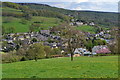
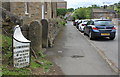
2
Hathersage view from the churchyard
View over the village from the elevated churchyard.
Image: © Andrew Hill
Taken: 14 Sep 2012
0.01 miles
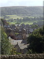
3
Hathersage cottages
Between Main Road and Crossland Road east of the village centre
Image: © Graham Hogg
Taken: 4 Oct 2019
0.02 miles
5
Turnpike road distance marker, Hathersage
A well-preserved (and conserved) relic from the pre-motor age.
Image: © Michael Fox
Taken: 14 May 2011
0.03 miles
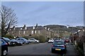
6
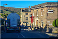
Hathersage : Main Road A6187
A road heading through Hathersage.
Image: © Lewis Clarke
Taken: 1 Oct 2018
0.04 miles
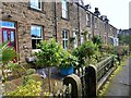
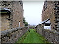
7
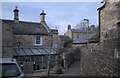
Passageway
Path from Ibbotson's Croft through to Main Road
Image: © Bob Harvey
Taken: 15 Feb 2023
0.04 miles
8
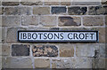
Road name
Ibbotsons Croft is a small yard of houses in Hathersage.
Image: © Bob Harvey
Taken: 15 Feb 2023
0.04 miles
9

Quoting Shakespeare
Plaque on a converted barn overlooking the path in Image, awarded by the Campaign for the Protection of Rural England.
Image: © Bob Harvey
Taken: 15 Feb 2023
0.05 miles
10
Gap between Dwellings, Hathersage
A green way leads between dwellings on Crossland Road in Hathersage, Derbyshire
Image: © Chris Heaton
Taken: 20 Sep 2011
0.05 miles