IMAGES TAKEN NEAR TO
Cannonfields, HOPE VALLEY, S32 1AG
Introduction
This page details the photographs taken nearby to Cannonfields, S32 1AG by members of the Geograph project.
The Geograph project started in 2005 with the aim of publishing, organising and preserving representative images for every square kilometre of Great Britain, Ireland and the Isle of Man.

There are currently over 7.5m images from over14,400 individuals and you can help contribute to the project by visiting https://www.geograph.org.uk
Image Map
Images are licensed for reuse under creativecommons.org/licenses/by-sa/2.0
Notes
- Clicking on the map will re-center to the selected point.
- The higher the marker number, the further away the image location is from the centre of the postcode.
Image Listing (57 Images Found)
Images are licensed for reuse under creativecommons.org/licenses/by-sa/2.0
Image
Details
Distance
1
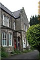
Looking across Jaggers Lane from the foot of Coggers Lane
A corner of the village of Hathersage.
Image: © Andrew Hill
Taken: 8 Aug 2013
0.01 miles
2

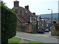
House on Jaggers Lane, Hathersage
With view across the Hope Valley
Image: © Neil Theasby
Taken: 20 Aug 2012
0.04 miles
3
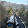
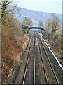
Hope Valley railway approaching Hathersage
With Hathersage Booths and Millstone Edge in the background.
Northern unit 195 133 of Class 195 passes en route with a stopping service from Manchester Piccadilly to Sheffield.
It's passing empty wagons going back to limestone quarries near Buxton.
The pedestrian level crossing in front of the stopping train was replaced by a footbridge within a week of this shot, see; https://www.geograph.org.uk/photo/7387829
Image: © Chris Morgan
Taken: 17 Jan 2023
0.05 miles
4
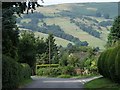
Coggers Lane, Hathersage
This section of the village is set on quite a steep hillside with views across the valley.
Image: © Andrew Hill
Taken: 8 Aug 2013
0.06 miles
5
New railway footbridge at Hathersage West
Positioned last night to replace the pedestrian level crossing immediately below it. The steps aren't installed yet.
Compare this late afternoon shot with a morning picture last week; https://www.geograph.org.uk/photo/7384293
Image: © Chris Morgan
Taken: 22 Jan 2023
0.06 miles
6
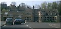
George Hotel in Hathersage
Only just inside the square. Where Station Road meets Main Road
Image: © Gary Barber
Taken: 24 Apr 2005
0.08 miles
7
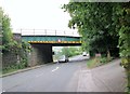
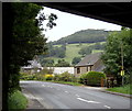
Castleton Road railway bridge
Our bed for the night is on the right, we never went under the bridge
Image: © Martin Dawes
Taken: 10 Sep 2015
0.09 miles
8
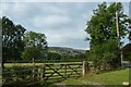
Gate beside Castleton Road
Looking into a field south of the A6187.
Image: © DS Pugh
Taken: 27 Aug 2022
0.10 miles
9
View from the railway bridge
The A6187 Castleton Road passes under the railway as it enters Hathersage from the west.
Image: © Andrew Hill
Taken: 14 Sep 2012
0.11 miles