IMAGES TAKEN NEAR TO
Glebe Avenue, SHEFFIELD, S26 7YS
Introduction
This page details the photographs taken nearby to Glebe Avenue, S26 7YS by members of the Geograph project.
The Geograph project started in 2005 with the aim of publishing, organising and preserving representative images for every square kilometre of Great Britain, Ireland and the Isle of Man.

There are currently over 7.5m images from over14,400 individuals and you can help contribute to the project by visiting https://www.geograph.org.uk
Image Map
Images are licensed for reuse under creativecommons.org/licenses/by-sa/2.0
Notes
- Clicking on the map will re-center to the selected point.
- The higher the marker number, the further away the image location is from the centre of the postcode.
Image Listing (55 Images Found)
Images are licensed for reuse under creativecommons.org/licenses/by-sa/2.0
Image
Details
Distance
4
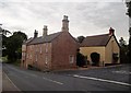
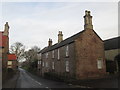
Junction of Hard Lane and Thorpe Road in Harthill
The impressive corner dwelling is The Hollies.
Image: © Jonathan Clitheroe
Taken: 7 Aug 2015
0.12 miles
6
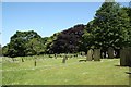
All Hallows churchyard
The northern side of All Hallows churchyard
Image: © Richard Croft
Taken: 1 Jun 2009
0.12 miles
8
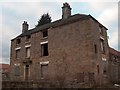
North House Farm - the old house, Harthill
Image: © Neil Theasby
Taken: 15 Feb 2012
0.12 miles
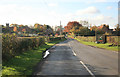
10
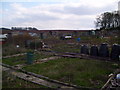
Allotments at Harthill
Allotments as seen from the junction of Thorpe Road and Glebe Farm Close.
Image: © Martin Speck
Taken: 5 Apr 2012
0.13 miles