IMAGES TAKEN NEAR TO
Harthill Field Road, SHEFFIELD, S26 7XS
Introduction
This page details the photographs taken nearby to Harthill Field Road, S26 7XS by members of the Geograph project.
The Geograph project started in 2005 with the aim of publishing, organising and preserving representative images for every square kilometre of Great Britain, Ireland and the Isle of Man.

There are currently over 7.5m images from over14,400 individuals and you can help contribute to the project by visiting https://www.geograph.org.uk
Image Map
Images are licensed for reuse under creativecommons.org/licenses/by-sa/2.0
Notes
- Clicking on the map will re-center to the selected point.
- The higher the marker number, the further away the image location is from the centre of the postcode.
Image Listing (9 Images Found)
Images are licensed for reuse under creativecommons.org/licenses/by-sa/2.0
Image
Details
Distance
4
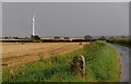
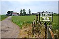
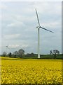
By Harthill Field Road
The lane passes by open arable fields, with an old post or milestone at this point. One of a small farm of three wind turbines in view, near Loscar Farm.
Image: © Andrew Hill
Taken: 25 Aug 2012
0.18 miles
5
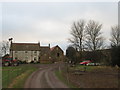
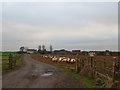
Entrance to Grange Farm, Harthill Field Road
Image: © Neil Theasby
Taken: 26 Jun 2012
0.18 miles
6
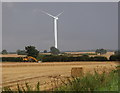
Wheat field and wind turbine
View from Harthill Field Road on another day with heavy shower passing through.
Image: © Andrew Hill
Taken: 25 Aug 2012
0.18 miles
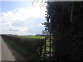
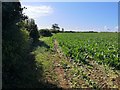
9
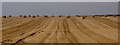
Large field on Loscar Common
View across a large wheat field just after harvest, seen from Harthill Field Road.
Image: © Andrew Hill
Taken: 25 Aug 2012
0.24 miles