IMAGES TAKEN NEAR TO
S26 7AE
Introduction
This page details the photographs taken nearby to S26 7AE by members of the Geograph project.
The Geograph project started in 2005 with the aim of publishing, organising and preserving representative images for every square kilometre of Great Britain, Ireland and the Isle of Man.

There are currently over 7.5m images from over14,400 individuals and you can help contribute to the project by visiting https://www.geograph.org.uk
Image Map
Images are licensed for reuse under creativecommons.org/licenses/by-sa/2.0
Notes
- Clicking on the map will re-center to the selected point.
- The higher the marker number, the further away the image location is from the centre of the postcode.
Image Listing (52 Images Found)
Images are licensed for reuse under creativecommons.org/licenses/by-sa/2.0
Image
Details
Distance
1
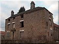
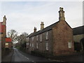
North House Farm - the old house, Harthill
Image: © Neil Theasby
Taken: 15 Feb 2012
0.01 miles
2
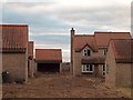
Ghostly housing estate at Harthill
A small housing development at North House Farm, Harthill. These "desirable" new houses are empty and mysteriously falling into dereliction. The access road remains undeveloped.
Image: © Neil Theasby
Taken: 15 Feb 2012
0.03 miles
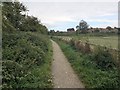
6
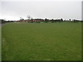
Big Grass Field
The village of Harthill is at the top of this hill. The bridleway to the left runs from Woodhall to Harthill.
Image: © Michael Patterson
Taken: 9 Apr 2006
0.06 miles
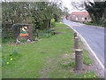
7
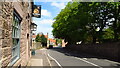
The Beehive PH & village street running north from Harthill
Image: © Richard Park
Taken: 11 May 2021
0.07 miles
8
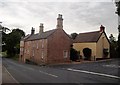
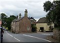
Junction of Hard Lane and Thorpe Road in Harthill
The impressive corner dwelling is The Hollies.
Image: © Jonathan Clitheroe
Taken: 7 Aug 2015
0.07 miles
9
Hard Lane/Thorpe Road, Harthill
Harthill, South Yorkshire
The junction of Hard Lane with Thorpe Road at the northern end of the village, looking towards Kiveton Park.
This image also appears on Flickr: https://www.flickr.com/photos/128783627@N03/35710820441/in/photostream/
Image: © Mike Nield
Taken: 7 Jul 2017
0.07 miles
10
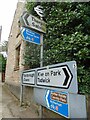
Direction Sign ? Signpost on Union Street, Harthill
Located in Harthill, against the front garden wall of 10 Union Street, opposite Thorpe Road, Harthill with Woodall parish. 1 modern arm and an annulus & bar finial.
Milestone Society National ID: YW_SK4981A
Image: © C Minto
Taken: 22 Aug 2021
0.07 miles