IMAGES TAKEN NEAR TO
Hillside Green, SHEFFIELD, S26 7AB
Introduction
This page details the photographs taken nearby to Hillside Green, S26 7AB by members of the Geograph project.
The Geograph project started in 2005 with the aim of publishing, organising and preserving representative images for every square kilometre of Great Britain, Ireland and the Isle of Man.

There are currently over 7.5m images from over14,400 individuals and you can help contribute to the project by visiting https://www.geograph.org.uk
Image Map
Images are licensed for reuse under creativecommons.org/licenses/by-sa/2.0
Notes
- Clicking on the map will re-center to the selected point.
- The higher the marker number, the further away the image location is from the centre of the postcode.
Image Listing (17 Images Found)
Images are licensed for reuse under creativecommons.org/licenses/by-sa/2.0
Image
Details
Distance
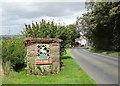
2
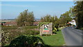
Approaching Harthill from the south
An attractive village entry sign on Winney Hill.
Image: © Andrew Hill
Taken: 28 Sep 2011
0.07 miles
4
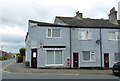
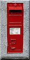
Victorian Wall Box, Harthill
Harthill, South Yorkshire
Harthill has the distinction of being the southernmost village in the county of Yorkshire, and this building – currently Auntie Rachel’s Dog Grooming – is situated near the top of Winney Hill at the junction with Firvale, right at the southern end of the village. The building is of interest, not because of its beauty or architectural value, but because it houses what must rank as the most southerly VR post box in Yorkshire. Postcode: S26 7YN.
This image also appears on Flickr: https://www.flickr.com/photos/128783627@N03/35771256676/in/photostream/
Image: © Mike Nield
Taken: 7 Jul 2017
0.09 miles
5
Victorian Wall Box, Harthill
Harthill, South Yorkshire
Not the most attractive backdrop for what must rank as the most southerly VR post box in Yorkshire, but it warrants a photo because of that distinction. This particular box is situated in the village of Harthill, near the top of Winney Hill at the junction with Firvale, right at the southern end of the village (see picture below).
Postcode: S26 7YN.
This image also appears on Flickr: https://www.flickr.com/photos/128783627@N03/35000987813/in/photostream/
Image: © Mike Nield
Taken: 7 Jul 2017
0.09 miles
7
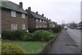
Airey Houses Prior Mede Harthill
Airey houses such as those pictured were built shortly after the Second World War under the Temporary Housing Programme 1944-49. The houses, which were constructed from pre-cast concrete panels, were meant to provide temporary accommodation but were often built to such a high stadard that many of them survive to this day.
Image: © Michael Patterson
Taken: 15 Jan 2006
0.17 miles
9
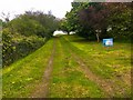
Access track to Harthill Service Reservoir
Image: © Graham Hogg
Taken: 7 May 2019
0.19 miles
10
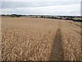
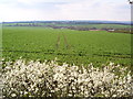
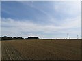
Field of Wheat near Harthill
There's a public footpath crossing this field near here but it looks like it's been ploughed out. Note also traffic on the M1 Motorway rumbling across the mid horizon.
Image: © Jonathan Clitheroe
Taken: 7 Aug 2015
0.20 miles