IMAGES TAKEN NEAR TO
Swallow Wood Road, SHEFFIELD, S26 4SZ
Introduction
This page details the photographs taken nearby to Swallow Wood Road, S26 4SZ by members of the Geograph project.
The Geograph project started in 2005 with the aim of publishing, organising and preserving representative images for every square kilometre of Great Britain, Ireland and the Isle of Man.

There are currently over 7.5m images from over14,400 individuals and you can help contribute to the project by visiting https://www.geograph.org.uk
Image Map
Images are licensed for reuse under creativecommons.org/licenses/by-sa/2.0
Notes
- Clicking on the map will re-center to the selected point.
- The higher the marker number, the further away the image location is from the centre of the postcode.
Image Listing (4 Images Found)
Images are licensed for reuse under creativecommons.org/licenses/by-sa/2.0
Image
Details
Distance
1
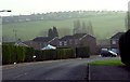
Swallownest - Wetherby Drive
Looking in an easterly direction from the main road to Swallownest.
Image: © Andrew Loughran
Taken: 24 Jan 2006
0.20 miles
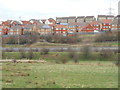
2
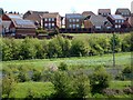
Modern housing at Swallownest
The solar panel salesman has been quite busy here!
Image: © Graham Hogg
Taken: 30 Apr 2012
0.21 miles
4
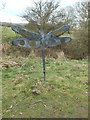
Marker Post
One of five posts indicating the former line of the River Rother
Image: © John Jennings
Taken: 19 Mar 2012
0.24 miles